Back ঝিনাইদহ জেলা Bengali/Bangla ঝিনাইদহ জিলা BPY Jhenaidah CEB Jhenaidah (Distrikt) German Jhenaidah (zila) Spanish ناحیه جنایده Persian Jhenaidah French झेनईदह जिला Hindi Distretto di Jhenaidah Italian ジェナイダ県 Japanese
Jhenaidah District
ঝিনাইদহ | |
|---|---|
|
From top: Payra chattar, Jhenaidah NunGola Masjid, Jhenaidah Golakata Mosque, Pir Pukur Masjid, Pathaghar Dhibi | |
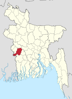
 Location of Jhenaidah District in Bangladesh | |
 Expandable map of Jhenaidah District | |
| Coordinates: 23°32′N 89°00′E / 23.54°N 89.00°E | |
| Country | |
| Division | Khulna |
| Headquarters | Jhenaidah |
| Government | |
| • Deputy Commissioner | Monira Begum |
| Area | |
| • Total | 1,964.77 km2 (758.60 sq mi) |
| Population (2022)[1] | |
| • Total | 2,005,849 |
| • Density | 1,000/km2 (2,600/sq mi) |
| Time zone | UTC+06:00 (BST) |
| HDI (2019) | 0.644[2] medium · 5th of 20 |
Jhenaidah District (Bengali: ঝিনাইদহ) is a district in southwestern Bangladesh. Part of the Khulna Division, the district has an area of 1,964.77 km2 (758.60 sq mi).[3] It is bordered by Kushtia District to the north, Jessore District and West Bengal, India to the south, Rajbari District and Magura District to the east, and Chuadanga District and West Bengal, India to the west. The largest city and headquarter of this district is Jhenaidah.[4] At the beginning of the British rule Jhenaidah was a police outpost and was turned into a thana in 1793. It is the smallest district in Bangladesh. The Jhenaidah sub-division was established in 1862. It became a district in 1984.[5]
- ^ Population and Housing Census 2022: Preliminary Report. Bangladesh Bureau of Statistics. August 2022. pp. viii, 29, 38, 45. ISBN 978-984-35-2977-0.
- ^ "Sub-national HDI – Area Database – Global Data Lab". hdi.globaldatalab.org. Retrieved 18 March 2020.
- ^ "Jhenaidah (District (Zila))". Retrieved 3 May 2013.
- ^ BM Rezaul Karim (2012). "Jhenaidah District". In Sirajul Islam and Ahmed A. Jamal (ed.). Banglapedia: National Encyclopedia of Bangladesh (Second ed.). Asiatic Society of Bangladesh.
- ^ "Jhenaidah District Town".
© MMXXIII Rich X Search. We shall prevail. All rights reserved. Rich X Search


