Back Erenköy/Kokkina German Κόκκινα Greek Kokkina Esperanto Erenköy Spanish کوکینا Persian Kókkina French Kokkina Hungarian Kokkina ID Kokkina Italian Kokina Lithuanian
This article needs additional citations for verification. (January 2015) |
Kokkina
| |
|---|---|
 | |
 | |
| Coordinates: 35°10′45″N 32°36′42″E / 35.17917°N 32.61167°E | |
| Country (de jure) | |
| • District | Nicosia District |
| Country (de facto) | |
| • District | Lefke District |
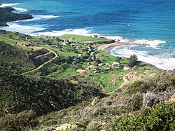
Kokkina (Greek: Κόκκινα, locally [ˈkot͡ʃːʰina]; Turkish: Erenköy or Koççina) is a coastal exclave (pene-exclave) of the de facto Northern Cyprus, and a former Turkish Cypriot enclave in Cyprus. It is surrounded by mountainous territory, with the Morphou Bay on its northern flank. Kokkina sits several kilometres west of mainland Northern Cyprus and is a place with symbolic significance to Cypriots,[citation needed] because of the events of August 1964 (cf. Battle of Tillyria). In 1976, all Kokkina inhabitants were transferred to Gialousa (renamed Yeni Erenköy or "New Erenköy" in Turkish) and the enclave has since functioned as a North Cyprus Defence Force military camp for the Turkish forces.[2]
- ^ In 1983, the Turkish Republic of Northern Cyprus unilaterally declared independence from the Republic of Cyprus. The de facto state is not recognised by any UN state except Turkey.
- ^ "KOKKINA". Internal Displacement in Cyprus. PRIO Cyprus Centre. Retrieved 14 January 2015.
© MMXXIII Rich X Search. We shall prevail. All rights reserved. Rich X Search
