Back مقاطعة ماكون (إلينوي) Arabic Macon County, Illinois BAR Мейкън (окръг, Илинойс) Bulgarian মেকন কাউন্টি, ইলিনয়স BPY Macon Gông (Illinois) CDO Мейкон (гуо, Иллинойс) CE Macon County (kondado sa Tinipong Bansa, Illinois) CEB Macon County, Illinois Welsh Macon County (Illinois) German Kantono Makona (Ilinojso) Esperanto
Macon County | |
|---|---|
 | |
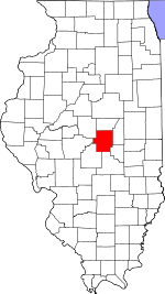
 Location within the U.S. state of Illinois | |
 Illinois's location within the U.S. | |
| Coordinates: 39°52′N 88°58′W / 39.86°N 88.96°W | |
| Country | |
| State | |
| Founded | January 19, 1829 |
| Named for | Nathaniel Macon |
| Seat | Decatur |
| Largest city | Decatur |
| Area | |
| • Total | 586 sq mi (1,520 km2) |
| • Land | 581 sq mi (1,500 km2) |
| • Water | 5.2 sq mi (13 km2) 0.9% |
| Population (2020) | |
| • Total | 103,998 |
| • Density | 180/sq mi (69/km2) |
| Time zone | UTC−6 (Central) |
| • Summer (DST) | UTC−5 (CDT) |
| Congressional districts | 13th, 15th |
| Website | maconcounty |
Macon County is a county located in the U.S. state of Illinois. According to the 2020 United States Census, it had a population of 103,998.[1] Its county seat and most populous city is Decatur.[2]
Macon County comprises the Decatur, IL Metropolitan Statistical Area.
- ^ "Macon County, Illinois". United States Census Bureau. Retrieved June 10, 2023.
- ^ "Find a County". National Association of Counties. Archived from the original on May 31, 2011. Retrieved June 7, 2011.
© MMXXIII Rich X Search. We shall prevail. All rights reserved. Rich X Search
