Back نهر ناكدونج ARZ ناکدونق چایی AZB Salog Nakdong BCL Нактанган Byelorussian Нактонган Bulgarian নাকডং নদী Bengali/Bangla Stêr Nakdong Breton Naktong-gang CEB Nakdong Czech Nakdonggang German
| Nakdong River | |
|---|---|
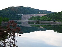
 The Nakdonggang in Andong, North Gyeongsang | |
 The Nakdonggang River | |
| Native name | 낙동강 (Korean) |
| Location | |
| Country | South Korea |
| Provinces | Gangwon, North Gyeongsang, Daegu, South Gyeongsang, Busan |
| Physical characteristics | |
| Source | Taebaek Mountains |
| • location | Eundae Peak, Taebaek, Gangwon[a][1] |
| Mouth | Sea of Japan |
• location | Estuary Bank, Gangseo, Busan |
| Length | 510 km (320 mi)[2] |
| Basin size | 23,384 km2 (9,029 sq mi)[2] |
| Discharge | |
| • location | Jindong, Haman[b][3] |
| • average | 383 m3/s (13,500 cu ft/s)[c][3] |
| Basin features | |
| Tributaries | |
| • left | Banbyeoncheon, Geumhogang River, Miryanggang River, Yangsancheon, West Nakdonggang River † |
| • right | Naeseongcheon, Gamcheon, Hwanggang River, Nam River |
| † : Distributary of Nakdonggang | |
| Nakdong River | |
| Hangul | 낙동강 |
|---|---|
| Hanja | |
| Revised Romanization | Nakdonggang |
| McCune–Reischauer | Naktonggang |

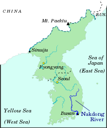
The Nakdong River or Nakdonggang (Korean: 낙동강, pronounced [nak̚t͈oŋgaŋ])[d] is the longest river in South Korea, which passes through the major cities of Daegu and Busan. It takes its name from its role as the eastern border of the Gaya confederacy during Korea's Three Kingdoms Era.
Cite error: There are <ref group=lower-alpha> tags or {{efn}} templates on this page, but the references will not show without a {{reflist|group=lower-alpha}} template or {{notelist}} template (see the help page).
- ^ 2013년 한국하천일람 [List of Rivers of South Korea, 2013] (PDF) (in Korean). Han River Flood Control Office, Republic of Korea. 31 December 2012. pp. 22, 25, 29, 136–137. Archived from the original (PDF) on 4 March 2016. Retrieved 7 July 2014.
- ^ a b HRFCO 2012 Archived 2016-03-04 at the Wayback Machine, pp. 22, 25, 33, 136-137.
- ^ a b 2014년 1월 월간 수자원 현황 및 전망 [Monthly Status & Predictions Report on Water Resources, January 2014] (in Korean). Han River Flood Control Office, Republic of Korea. 13 January 2014. p. 3. Archived from the original (HWP) on 15 July 2014. Retrieved 17 July 2014.
- ^ EB (1878), p. 390.
© MMXXIII Rich X Search. We shall prevail. All rights reserved. Rich X Search