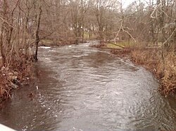
| Pequonnock River | |
|---|---|
 Upriver view from the Daniels Farm Road bridge in Trumbull, CT. | |
| Location | |
| Country | United States |
| State | Connecticut |
| Counties | Fairfield |
| Physical characteristics | |
| Source | Pequonnock River Watershed |
| • location | Lantern Drive & CT Route 25, Monroe, Connecticut, United States |
| Mouth | Bridgeport Harbor Light on Long Island Sound |
• location | Bridgeport, Fairfield County, Connecticut, United States |
• coordinates | 41°09′24″N 73°10′48″W / 41.15667°N 73.18000°W |
• elevation | 0 ft (0 m) |
| Length | 16.7 mi (26.9 km) |
| Basin size | 0.125 sq mi (0.32 km2) |
| Discharge | |
| • location | Bridgeport, Connecticut |
The Pequonnock River is a 16.7-mile-long (26.9 km)[1] waterway in eastern Fairfield County, Connecticut. Its watershed is located in five communities, with the majority of it located within Monroe, Trumbull, and Bridgeport. The river has a penchant for flooding, particularly in spring since the removal of a retention dam in Trumbull in the 1950s.[2] There seems to be a sharp difference of opinion among historians as to just what the Indian word Pequonnock signifies. Some insist it meant cleared field or open ground; others are sure it meant broken ground; while a third group is certain it meant place of slaughter or place of destruction.[3][4]
- ^ U.S. Geological Survey. National Hydrography Dataset high-resolution flowline data. The National Map Archived 2012-03-29 at the Wayback Machine, accessed 2011-04-01.
- ^ "THE WEEK; Towns Seek Flood-Prevention Solutions". The New York Times. 6 May 2007.
- ^ Elsie Nicholas Danenberg, The Story of Bridgeport, The Bridgeport Centennial, Inc., 1936, p. 20
- ^ Dorothy Seeley, Tales of Trumbull's Past, Trumbull Historical Society, 1984, p. 337
© MMXXIII Rich X Search. We shall prevail. All rights reserved. Rich X Search
