Back Taymır Dolqan-Nenes rayonu Azerbaijani Таймырскі Далгана-Ненецкі раён Byelorussian Таймыран Долганойн-Ненцойн кӀошт CE Taymyrsky Dolgano-Nenetsky District CEB Taimõri rajoon Estonian Taimyrin dolgaanien ja nenetsien piiri Finnish Raïon dolgano-nénètse de Taïmyr French Tajmiri Dolgan–Nyenyec járás Hungarian Թայմիրսկի Դոլգանո-Նենեցկի շրջան Armenian Tajmyrskij rajon Italian
72°00′N 95°00′E / 72.000°N 95.000°E
Taymyrsky Dolgano-Nenetsky District
Таймырский Долгано-Ненецкий район | |
|---|---|
 Geological outcrops "Motley rocks" (Popigai astrobleme) | |
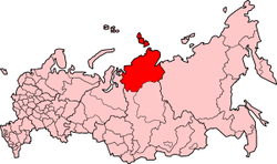
 Location of Taymyrsky Dolgano-Nenetsky District in Krasnoyarsk Krai | |
| Coordinates: 58°N 87°E / 58°N 87°E | |
| Country | Russia |
| Federal subject | Krasnoyarsk Krai[1] |
| Established | April 10, 1930[2] |
| Administrative center | Dudinka[1] |
| Government | |
| • Type | Local government |
| • Body | Duma[3] |
| • Head[4] | Sergey V. Baturin[2] |
| Area | |
| • Total | 897,900 km2 (346,700 sq mi) |
| Population | |
| • Total | 34,432 |
| • Estimate (2018)[6] | 31,762 (−7.8%) |
| • Density | 0.038/km2 (0.099/sq mi) |
| • Urban | 66.4% |
| • Rural | 33.6% |
| Administrative structure | |
| • Administrative divisions | 1 District towns, 1 Urban-type settlements, 2 Selsoviets |
| • Inhabited localities[1] | 1 cities/towns, 1 Urban-type settlements[7], 25 rural localities |
| Municipal structure | |
| • Municipally incorporated as | Taymyrsky Dolgano-Nenetsky Municipal District[8] |
| • Municipal divisions[8] | 2 urban settlements, 2 rural settlements |
| Time zone | UTC+7 (MSK+4 |
| OKTMO ID | 04653000 |
| Website | http://www.taimyr24.ru/ |
Taymyrsky Dolgano-Nenetsky District (Russian: Таймы́рский Долга́но-Не́нецкий райо́н) is an administrative[1] and municipal[8] district (raion), one of the forty-three in Krasnoyarsk Krai, Russia. It is located in the north of the krai above the Arctic Circle on the Taymyr Peninsula and borders with Laptev and Kara Seas in the north, the Sakha Republic in the east, Evenkiysky and Turukhansky Districts in the south, and with Yamalo-Nenets Autonomous Okrug in the west. The area of the district is 879,900 square kilometers (339,700 sq mi).[2] Its administrative center is the town of Dudinka,[1] which accounts for 64.4% of the district's total population.[5] The 2010 Russian census counted 34,432 people in the whole district, as opposed to 39,786 (2002 Census) in 2002, [10] and 55,111 (1989 Soviet census)[11] in 1989.
Norilsk is an enclave surrounded by, but independent from, Taymyrsky Dolgano-Nenetsky District. In 2005, the central city of Norilsk merged with its satellite cities or neighborhoods (Talnakh and Kayerkan) as a municipal division. Greater Norilsk, or Big Norilsk (Russian: «Большой Норильск» ), is the Norilsk Industrial Region (Russian: Нори́льский промы́шленный райо́н, (НПР)) and is the Krai city. Greater Norilsk includes Norilsk, the remote area (Russian: отдалённый район) of Oganer, and the urban-type settlement of Snezhnogorsk and is equal to a district within the Krasnoyarsk Krai and is not part of the Taymyrsky Dolgano-Nenetsky District.[12][13]
- ^ a b c d e Law #10-4765
- ^ a b c d Official website of Krasnoyarsk Krai. Information about Taymyrsky Dolgano-Nenetsky District (in Russian)
- ^ Charter of Taymyrsky Dolgano-Nenetsky District, Article 20.2
- ^ Charter of Taymyrsky Dolgano-Nenetsky District, Article 20.1
- ^ a b Russian Federal State Statistics Service (2011). Всероссийская перепись населения 2010 года. Том 1 [2010 All-Russian Population Census, vol. 1]. Всероссийская перепись населения 2010 года [2010 All-Russia Population Census] (in Russian). Federal State Statistics Service.
- ^ "26. Численность постоянного населения Российской Федерации по муниципальным образованиям на 1 января 2018 года". Federal State Statistics Service. Retrieved January 23, 2019.
- ^ The count of urban-type settlements may include the work settlements, the resort settlements, the suburban (dacha) settlements, as well as urban-type settlements proper.
- ^ a b c Law #2-54
- ^ "Об исчислении времени". Официальный интернет-портал правовой информации (in Russian). June 3, 2011. Retrieved January 19, 2019.
- ^ Federal State Statistics Service (May 21, 2004). Численность населения России, субъектов Российской Федерации в составе федеральных округов, районов, городских поселений, сельских населённых пунктов – районных центров и сельских населённых пунктов с населением 3 тысячи и более человек [Population of Russia, Its Federal Districts, Federal Subjects, Districts, Urban Localities, Rural Localities—Administrative Centers, and Rural Localities with Population of Over 3,000] (XLS). Всероссийская перепись населения 2002 года [All-Russia Population Census of 2002] (in Russian).
- ^ Всесоюзная перепись населения 1989 г. Численность наличного населения союзных и автономных республик, автономных областей и округов, краёв, областей, районов, городских поселений и сёл-райцентров [All Union Population Census of 1989: Present Population of Union and Autonomous Republics, Autonomous Oblasts and Okrugs, Krais, Oblasts, Districts, Urban Settlements, and Villages Serving as District Administrative Centers]. Всесоюзная перепись населения 1989 года [All-Union Population Census of 1989] (in Russian). Институт демографии Национального исследовательского университета: Высшая школа экономики [Institute of Demography at the National Research University: Higher School of Economics]. 1989 – via Demoscope Weekly.
- ^ Официальный сайт города Норильск: Территориальные управления [Official website city of Norilsk: Territorial management]. www.norilsk-city.ru (in Russian). Retrieved November 16, 2016.
- ^ Норильск: Генеральный план городского округа [Norilsk: General map of municipal region]. www.norilsk-city.ru (in Russian). Retrieved November 16, 2016.
© MMXXIII Rich X Search. We shall prevail. All rights reserved. Rich X Search

