Back فريدريشسهاين-كرويتزبيرغ Arabic Friedrichshain-Kreuzberg Breton Friedrichshain-Kreuzberg Catalan Friedrichshain-Kreuzberg Czech Friedrichshain-Kreuzberg Danish Bezirk Friedrichshain-Kreuzberg German Friedrichshain-Kreuzberg DIQ Φρίντριχσχαϊν-Κρόιτσμπεργκ Greek Friedrichshain-Kreuzberg Esperanto Friedrichshain-Kreuzberg Spanish
You can help expand this article with text translated from the corresponding article in German. (August 2020) Click [show] for important translation instructions.
|
Friedrichshain-Kreuzberg | |
|---|---|
| Coordinates: 52°30′N 13°27′E / 52.500°N 13.450°E | |
| Country | Germany |
| State | Berlin |
| City | Berlin |
| Subdivisions | 2 localities |
| Government | |
| • Borough Mayor | Clara Herrmann (Greens) |
| Area | |
| • Total | 20.16 km2 (7.78 sq mi) |
| Population (2020-12-31)[1] | |
| • Total | 289,787 |
| • Density | 14,000/km2 (37,000/sq mi) |
| Time zone | UTC+01:00 (CET) |
| • Summer (DST) | UTC+02:00 (CEST) |
| Vehicle registration | B |
| Website | official homepage |
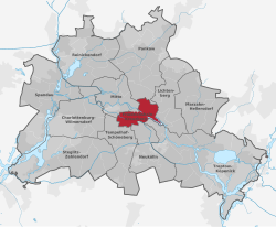
Friedrichshain-Kreuzberg (German: [ˈfʁiːdʁɪçsˌhaɪn ˈkʁɔʏtsbɛʁk] ) is the second borough of Berlin, formed in 2001 by merging the former East Berlin borough of Friedrichshain and the former West Berlin borough of Kreuzberg. The historic Oberbaum Bridge, formerly a Berlin border crossing for pedestrians, links both districts across the river Spree as the new borough's landmark (as featured in the coat of arms).

The counterculture tradition especially of Kreuzberg has led to the borough being a stronghold for the Green Party. While Kreuzberg is characterised by a high number of immigrants, the share of non-German citizens in Friedrichshain is much lower and the average age is higher. The merger between the distinct quarters is celebrated by an annual anarchic "vegetable fight" on the Oberbaumbrücke. Both parts have to deal with the consequences of gentrification.
- ^ "Einwohnerinnen und Einwohner im Land Berlin am 31. Dezember 2020" (PDF). Amt für Statistik Berlin-Brandenburg. February 2021. Archived from the original (PDF) on 4 September 2021. Retrieved 21 September 2021.
© MMXXIII Rich X Search. We shall prevail. All rights reserved. Rich X Search


