Back 10.º distrito congresional de Georgia Spanish حوزه انتخابیه دهم جورجیا Persian Dixième district congressionnel de Géorgie French 10.º Distrito Congressional da Geórgia Portuguese
| Georgia's 10th congressional district | |||
|---|---|---|---|
Interactive map of district boundaries | |||
| Representative |
| ||
| Distribution |
| ||
| Population (2022) | 806,637[2] | ||
| Median household income | $73,988[3] | ||
| Ethnicity |
| ||
| Cook PVI | R+15[4] | ||
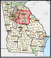
Georgia's 10th congressional district is a congressional district in the U.S. state of Georgia. The district is currently represented by Republican Mike Collins, and includes a large swath of urban and rural territory between Atlanta and Augusta.
The district's boundaries were redrawn following the 2010 census, which granted an additional congressional seat to Georgia.[5] The first election using the new district boundaries (listed below) were the 2012 congressional elections.
Located in the eastern part of the state, the district boundaries include the cities of Athens, Eatonton, Jackson, Milledgeville, Monroe, Washington, Watkinsville, Winder, and Wrightsville.[6]
- ^ "Congressional Districts Relationship Files (State-based) - Geography - U.S. Census Bureau". Archived from the original on April 2, 2013.
- ^ "My Congressional District".
- ^ "My Congressional District".
- ^ "2022 Cook PVI: District Map and List". Cook Political Report. Retrieved January 10, 2023.
- ^ Justice Department approves Georgia's political maps Archived January 7, 2012, at the Wayback Machine. Atlanta Journal-Constitution. Last accessed 2011-12-27
- ^ 2012 Congressional maps, Georgia Legislature, last accessed 2012-1-1
© MMXXIII Rich X Search. We shall prevail. All rights reserved. Rich X Search


