Back Havel Afrikaans Hæfel ANG نهر هافل Arabic نهر هافل ARZ Hafel çayı Azerbaijani هاول چایی AZB Havel BAR Хафель Byelorussian Гафэль BE-X-OLD Хафел Bulgarian
| Havel | |
|---|---|
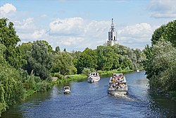
 The Havel in Potsdam | |
 Rivers Havel (dark blue) and Rhin (turquoise) | |
| Location | |
| Country | Germany |
| States | |
| Physical characteristics | |
| Source | |
| • location | Ankershagen, Mecklenburg |
| • coordinates | 53°28′04″N 12°56′08″E / 53.467778°N 12.935556°E |
| • elevation | 65 m (213 ft) |
| Mouth | |
• location | Rühstädt-Gnevsdorf |
• coordinates | 52°54′30″N 11°52′38″E / 52.908333°N 11.877222°E |
• elevation | 22 m (72 ft) |
| Length | 324 km (201 miles) |
| Basin size | 23,858 km2 (9,212 sq mi) |
| Discharge | |
| • location | Havelberg |
| • average | 103 m3/s (3,600 cu ft/s) |
| • minimum | 18.8 m3/s (660 cu ft/s) |
| • maximum | 215 m3/s (7,600 cu ft/s) |
| Basin features | |
| Progression | Elbe→ North Sea |
| Tributaries | |
| • left | Woblitz, Briese, Tegeler Fließ, Spree, Nuthe, Plane, Buckau |
| • right | Rhin, Dosse |
The Havel (German: [ˈhaːfl̩] ⓘ)[1] is a river in northeastern Germany, flowing through the states of Mecklenburg-Vorpommern, Brandenburg, Berlin and Saxony-Anhalt. The 325 kilometres (202 mi) long Havel is a right tributary of the Elbe. However, the direct distance from its source to its mouth is only 94 kilometres (58 mi). For much of its length, the Havel is navigable; it provides an important link in the waterway connections between the east and west of Germany, as well as beyond.
© MMXXIII Rich X Search. We shall prevail. All rights reserved. Rich X Search