Back مقاطعة هاوارد (ميزوري) Arabic هاوارد بؤلگهسی، میزوری AZB Howard County, Missouri BAR Хауърд (окръг, Мисури) Bulgarian হাৱার্ড কাউন্টি, মিসৌরি BPY Howard Gông (Missouri) CDO Хауард (гуо, Миссури) CE Howard County (kondado sa Tinipong Bansa, Missouri) CEB Howard County, Missouri Welsh Howard County (Missouri) German
Howard County | |
|---|---|
 The Howard County Courthouse in Fayette | |
| Nickname: Mother of Counties | |
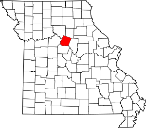
 Location within the U.S. state of Missouri | |
 Missouri's location within the U.S. | |
| Coordinates: 39°08′N 92°42′W / 39.14°N 92.7°W | |
| Country | |
| State | |
| Founded | January 23, 1816 |
| Named for | Benjamin Howard |
| Seat | Fayette |
| Largest city | Fayette |
| Area | |
| • Total | 472 sq mi (1,220 km2) |
| • Land | 464 sq mi (1,200 km2) |
| • Water | 7.7 sq mi (20 km2) 1.6% |
| Population (2020) | |
| • Total | 10,151 |
| • Density | 22/sq mi (8.3/km2) |
| Time zone | UTC−6 (Central) |
| • Summer (DST) | UTC−5 (CDT) |
| Congressional district | 4th |
Howard County is located in the U.S. state of Missouri, with its southern border formed by the Missouri River. As of the 2020 census, the population was 10,151.[1] Its county seat is Fayette.[2] The county was organized January 23, 1816, and named for Benjamin Howard, the first Governor of the Missouri Territory.[3] Settled originally by migrants from the Upper South, it is part of the region historically known as Little Dixie. It is part of the Columbia, Missouri, metropolitan area.
- ^ "Explore Census Data". data.census.gov. Retrieved January 5, 2022.
- ^ "Find a County". National Association of Counties. Archived from the original on May 31, 2011. Retrieved June 7, 2011.
- ^ Eaton, David Wolfe (1916). How Missouri Counties, Towns and Streams Were Named. The State Historical Society of Missouri. pp. 174.
© MMXXIII Rich X Search. We shall prevail. All rights reserved. Rich X Search