Back آسيا الداخلية Arabic Àsia interior Catalan ئاسیای ناوەوە CKB Εσωτερική Ασία Greek Sise-Aasia Estonian آسیای داخلی Persian Asie intérieure French Belső-Ázsia Hungarian Asia Dalam ID Asia interna Italian
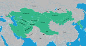
Inner Asia refers to the northern and landlocked regions spanning North, Central and East Asia. It includes parts of western and northeast China, as well as southern Siberia. The area overlaps with some definitions of "Central Asia", mostly the historical ones, but certain regions that are often included in Inner Asia, such as Manchuria, are not a part of Central Asia by any of its definitions. Inner Asia may be regarded as the western and northern "frontier" of China proper and as being bounded by East Asia proper, which consists of China proper, Japan and Korea.[1]
The extent of Inner Asia has been understood differently in different periods. "Inner Asia" is sometimes contrasted to "China proper", that is, the territories originally unified under the Qin dynasty with majority Han populations. In 1800, Chinese Inner Asia consisted of four main areas, namely Manchuria (modern Northeast China and Outer Manchuria), the Mongolian Plateau (Inner Mongolia and Outer Mongolia), Xinjiang (Chinese Turkestan or East Turkestan), and Tibet. Many of these areas had been only recently conquered by the Qing dynasty of China and, during most of the Qing period, they were governed through administrative structures different from those of the older Chinese provinces.[2] A Qing government agency, the Lifan Yuan, supervised the empire's Inner Asian regions, also known as Chinese Tartary.
- ^ Bulag, Uradyn E. (October 2005). "Where is East Asia?: Central Asian and Inner Asian Perspectives on Regionalism". Japan Focus.
- ^ The Cambridge History of China: Volume 10, Part 1, by John K. Fairbank, p37
© MMXXIII Rich X Search. We shall prevail. All rights reserved. Rich X Search

