Back المنطقة المنزوعة السلاح (كوريا) Arabic Koreya silahsızlaşdırılmış zonası Azerbaijani Дэмілітарызаваная зона (Карэя) Byelorussian Корейска демилитаризирана зона Bulgarian কোরীয় অসামরিকীকৃত অঞ্চল Bengali/Bangla Zona desmilitaritzada de Corea Catalan ناوچەی داماڵراوی سەربازیی کۆری CKB Korejské demilitarizované pásmo Czech Koreanske demilitariserede zone Danish Demilitarisierte Zone (Korea) German
| Korean Demilitarized Zone | |
|---|---|
한반도 비무장 지대 | |
| Korean Peninsula | |
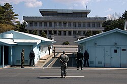
 View of the North from the southern side of the Joint Security Area | |
 The Korean DMZ denoted by the red highlighted area. The blue line indicates the international border. The four incursion tunnels are also shown. | |
| Type | DMZ |
| Length | 250 km (160 mi) |
| Site information | |
| Open to the public | No access; access only granted by North Korea or United Nations Command. |
| Condition | Fully manned and operational |
| Site history | |
| Built by | |
| In use | since 27 July 1953 (70 years ago) |
| Events | Division of Korea |
| Korean name | |
| Hangul | 한반도 비무장 지대 |
| Hanja | 韓半島非武裝地帶 |
| Revised Romanization | Hanbando Bimujang jidae |
| McCune–Reischauer | Hanbando Pimujang chidae |
The Korean Demilitarized Zone (Korean: 한반도 비무장 지대) is a strip of land running across the Korean Peninsula near the 38th parallel north. The demilitarized zone (DMZ) is a border barrier that divides the peninsula roughly in half. It was established to serve as a buffer zone between the countries of North Korea and South Korea under the provisions of the Korean Armistice Agreement in 1953, an agreement between North Korea, China, and the United Nations Command.
The DMZ is 250 kilometers (160 mi) long and about 4 kilometers (2.5 mi) wide. There have been various incidents in and around the DMZ, with military and civilian casualties on both sides. Within the DMZ is a meeting point between the two nations, where negotiations take place: the small Joint Security Area (JSA) near the western end of the zone.
© MMXXIII Rich X Search. We shall prevail. All rights reserved. Rich X Search