Back Kuta, Kuta, Badung BAN Kuta (lungsod) CEB Kuta German Kuta, Kuta, Badung GOR Kuta, Kuta, Badung ID Kuta, Kuta, Badung JV 쿠타 (인도네시아) Korean Kuta, Kuta Malay Kuta (Badung) Dutch Kuta (ort) Swedish
Kuta
ᬓᬸᬢ (Balinese) | |
|---|---|
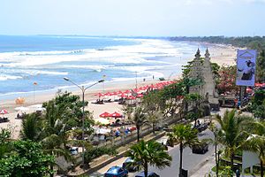
 Kuta Beach | |
Location in Badung Regency and Indonesia | |
| Coordinates: 8°44′S 115°10′E / 8.733°S 115.167°E | |
| Country | Indonesia |
| Province | Bali |
| Regency | Badung |
| District | Kuta |
Kuta is a tourist area, administratively an urban village (kelurahan), and the capital of Kuta District, Badung Regency, southern Bali, Indonesia. Kuta is a part of the Denpasar metropolitan area, 12 km (7.5 mi) south of downtown Denpasar. Originally known as a fishing village, it was one of the first towns on Bali to see substantial tourism, and as a beach resort remains one of Indonesia's major tourist destinations. It is known internationally for its long sandy beach, varied accommodations, restaurants and bars, and many renowned surfers who visit from Australia. It is near Bali's Ngurah Rai Airport.
The Balinese Provincial Government has taken the view that the preservation of the Balinese culture, natural resources, and wildlife are of primary importance in the island's development. To this end, it has limited tourist development to the peninsula on the island's extreme southern aspect; Kuta beach is on this peninsula's western side and Sanur is on the east. To the north of the peninsula no new tourist development is supposedly permitted.[1][2]
To the south, Kuta Beach extends beyond the airport into Jimbaran. Other nearby towns and villages include Seseh (6.4 nm), Denpasar (4.5 nm), Ujung (1.8 nm), Pesanggaran (2.0 nm), Kedonganan (2.9 nm), and Tuban (1.0 nm).
- ^ ANTARA. "Membentengi Kelestarian Alam di Bali dengan Ritual Sakral". gaya hidup. Archived from the original on 2018-12-23. Retrieved 2018-12-22.
- ^ www.gesuri.id. "Pemprov Bali Tetapkan Biaya Kontribusi bagi Wisatawan". gesuri.id/ (in Indonesian). Archived from the original on 2018-12-23. Retrieved 2018-12-22.
© MMXXIII Rich X Search. We shall prevail. All rights reserved. Rich X Search

