Back ماريفيل (ميزوري) Arabic مریویل، میزوری AZB Мэрывіл (Місуры) Byelorussian Maryville (Missouri) Catalan Меривилл (Миссури) CE Maryville (kapital sa kondado sa Tinipong Bansa, Missouri) CEB Maryville, Missouri Welsh Maryville (Missouri) Danish Maryville DAG Maryville (Missouri) German
Maryville, Missouri | |
|---|---|
City | |
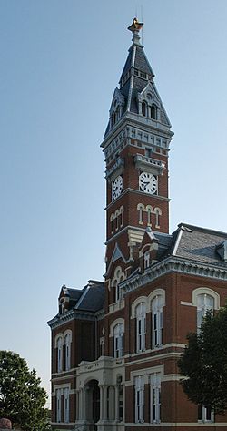
 Nodaway County Courthouse, 2006 | |
| Nickname: Title Town | |
 Location within Nodaway County and Missouri | |
 U.S. Census Map of Maryville | |
| Coordinates: 40°20′43″N 94°52′16″W / 40.34528°N 94.87111°W[1] | |
| Country | United States |
| State | Missouri |
| County | Nodaway |
| Platted | 1845 |
| Government | |
| • Type | Mayor–Council |
| • Mayor | Benjamin Lipiec |
| • City manager | Greg McDanel[2] |
| • City clerk | Sheila Smail[2] |
| Area | |
| • Total | 6.41 sq mi (16.59 km2) |
| • Land | 6.37 sq mi (16.51 km2) |
| • Water | 0.03 sq mi (0.08 km2) |
| Elevation | 1,106 ft (337 m) |
| Population (2020) | |
| • Total | 10,633 |
| • Density | 1,668.18/sq mi (644.06/km2) |
| Time zone | UTC-6 (CST) |
| • Summer (DST) | UTC-5 (CDT) |
| ZIP code | 64468[4] |
| Area code | 660 |
| FIPS code | 29-46640 |
| GNIS feature ID | 2395037[1] |
| Website | City website |
Maryville is a city and county seat of Nodaway County, Missouri, United States.[1] Located in the "Missouri Point" region, As of the 2020 census, the city population was 10,633.[5] Maryville is home to Northwest Missouri State University and Northwest Technical School. Maryville is the second largest city (first is St. Joseph, Missouri) wholly within the boundaries of the 1836 Platte Purchase which expanded Missouri's borders into former Indian Territory in northwest Missouri.
- ^ a b c d U.S. Geological Survey Geographic Names Information System: Maryville, Missouri
- ^ a b "Maryville, Missouri – Official Website". Maryville.org. Retrieved July 5, 2016.
- ^ "ArcGIS REST Services Directory". United States Census Bureau. Retrieved August 28, 2022.
- ^ United States Postal Service (2012). "USPS – Look Up a ZIP Code". Retrieved February 15, 2012.
- ^ "U.S. Census Bureau QuickFacts: Maryville, MO". U.S. Census Bureau QuickFacts. Retrieved March 4, 2022.
© MMXXIII Rich X Search. We shall prevail. All rights reserved. Rich X Search