Back Newark Liberty Internasionale Lughawe Afrikaans مطار نيوآرك ليبرتي الدولي Arabic مطار نيوآرك ليبرتى الدولى ARZ Aeropuertu Internacional Newark Liberty AST নিউয়ার্ক লিবার্টি আন্তর্জাতিক বিমানবন্দর Bengali/Bangla Aeroport Internacional de Newark Liberty Catalan Newark Liberty International Airport CEB Mezinárodní letiště Newark Liberty Czech Newark Liberty International Airport Danish Newark Liberty International Airport German
Newark Liberty International Airport | |||||||||||||||||||
|---|---|---|---|---|---|---|---|---|---|---|---|---|---|---|---|---|---|---|---|
 | |||||||||||||||||||
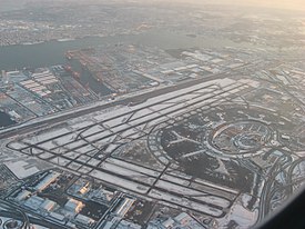
 Aerial view of Newark Liberty International Airport in 2009. | |||||||||||||||||||
| Summary | |||||||||||||||||||
| Airport type | Public | ||||||||||||||||||
| Owner/Operator | Port Authority of New York and New Jersey | ||||||||||||||||||
| Serves | New York metropolitan area | ||||||||||||||||||
| Location | Newark, Essex County and Elizabeth, Union County, New Jersey, United States | ||||||||||||||||||
| Opened | October 1, 1928 | ||||||||||||||||||
| Hub for | |||||||||||||||||||
| Coordinates | 40°41′33″N 074°10′07″W / 40.69250°N 74.16861°W | ||||||||||||||||||
| Website | newarkairport | ||||||||||||||||||
| Maps | |||||||||||||||||||
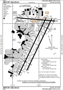
 FAA diagram | |||||||||||||||||||
 | |||||||||||||||||||
| Runways | |||||||||||||||||||
| |||||||||||||||||||
| Helipads | |||||||||||||||||||
| |||||||||||||||||||
| Statistics (2023) | |||||||||||||||||||
| |||||||||||||||||||
Newark Liberty International Airport[a] (IATA: EWR, ICAO: KEWR, FAA LID: EWR) is an international airport straddling the boundary between the cities of Newark in Essex County and Elizabeth in Union County, New Jersey, in the United States. Located about 4.5 miles (7.2 km) south of downtown Newark and 9 miles (14 km) west-southwest of Manhattan in New York City, it is a major gateway to points in Europe, South America, Asia, and Oceania. It is jointly owned by the cities and leased to its operator, the Port Authority of New York and New Jersey.[3] It is the second-busiest airport in the New York airport system behind John F. Kennedy International Airport but far ahead of LaGuardia Airport.
The airport is near the Newark Airport Interchange, the junction between Interstate 95 and Interstate 78, both of which are components of the New Jersey Turnpike, and U.S. Routes 1 and 9, which has junctions with U.S. Route 22, Route 81, and Route 21. AirTrain Newark connects the terminals with the Newark Liberty International Airport Station. The station is served by NJ Transit's Northeast Corridor Line and North Jersey Coast Line. Amtrak's Northeast Regional and Keystone Service trains also stop at the station.
The City of Newark built the airport on 68 acres (28 ha) of marshland in 1928, and the Army Air Corps operated the facility during World War II. The airport was constructed adjacent to Port Newark and U.S. Route 1. After the Port Authority took it over in 1948, an instrument runway, a terminal building, a control tower, and an air cargo center were added. The airport's Building One from 1935 was added to the U.S. National Register of Historic Places in 1980.
During 2022, the airport served 43.4 million passengers, which made it the 13th-busiest airport in the nation and the 23rd-busiest airport in the world. The busiest year to date was 2019 when it served 46.3 million passengers. Newark serves 50 carriers and is the largest hub for United Airlines by available seat miles. The airline serves about 63% of passengers at EWR making it the largest tenant at the airport. United and FedEx Express, its second-largest tenant, operate in three buildings on 2 million square feet (0.19 km2) of airport property.
- ^ Cite error: The named reference
ReferenceAwas invoked but never defined (see the help page). - ^ "EWR (KEWR): NEWARK LIBERTY INTL, NEWARK, NJ - UNITED STATES". Aeronautical Information Service. Federal Aviation Administration. December 30, 2021. Archived from the original on March 18, 2022. Retrieved January 20, 2022.
- ^ "Property owned and leased by the Port Authority" (PDF). Port Authority of New York and New Jersey. January 16, 2015. Archived (PDF) from the original on January 5, 2016. Retrieved October 20, 2015.
Cite error: There are <ref group=lower-alpha> tags or {{efn}} templates on this page, but the references will not show without a {{reflist|group=lower-alpha}} template or {{notelist}} template (see the help page).
© MMXXIII Rich X Search. We shall prevail. All rights reserved. Rich X Search