Back Palmyra-atol Afrikaans جزر بالميرا المرجانية Arabic Palmira rifi Azerbaijani Palmyra (Atoll) BAR Пальміра (атол) Byelorussian Пальміра (атол) BE-X-OLD Палмира (остров) Bulgarian Atol Palmyra BS Atol Palmyra Catalan Пальмира (атолл) CE
Palmyra Atoll | |
|---|---|
| Territory of Palmyra Island | |
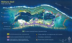
 Palmyra Atoll visitor access map | |
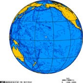
 Location of Palmyra Atoll in the Pacific Ocean | |
| Sovereign state | |
| Annexed by the United States | June 14, 1900 |
| Named for | U.S. trading ship Palmyra |
| Government | National Wildlife Refuge |
• Administered by | United States Fish and Wildlife Service |
• Superintendent | Laura Beauregard, Pacific Remote Islands Marine National Monument |
| Area | |
• Land | 11.9 km2 (4.6 sq mi) |
• Water | 0 km2 (0 sq mi) |
| Dimensions | |
• Length | 4.7 km (2.9 mi) |
• Width | 6.8 km (4.2 mi) |
| Elevation | 2.1 m (7 ft) |
| Highest elevation (Sand Island) | 10 m (30 ft) |
| Lowest elevation | 0 m (0 ft) |
| Population | |
• 2019 estimate | 4–20 staff and scientists |
| Currency | United States dollar (US$) (USD) |
| Time zone | UTC−11:00 (SST) |
| ISO 3166 code | |
| Internet TLD | .us |
| Designated | 2001 |
| Official name | Palmyra Atoll National Wildlife Refuge |
| Designated | April 1, 2011 |
| Reference no. | 1971[1] |

Palmyra Atoll (/pælˈmaɪrə/), also referred to as Palmyra Island, is one of the Northern Line Islands (southeast of Kingman Reef and north of Kiribati). It is located almost due south of the Hawaiian Islands, roughly one-third of the way between Hawaii and American Samoa. North America is about 3,300 miles (5,300 kilometers) northeast and New Zealand the same distance southwest, placing the atoll at the approximate center of the Pacific Ocean. The land area is 4.6 sq mi (12 km2), with about 9 miles (14 km) of sea-facing coastline and reef. There is one boat anchorage, known as West Lagoon, accessible from the sea by a narrow artificial channel and an old airstrip; during WW2 it was turned into Naval Air Station for several years and used for training and refueling. It was shelled by a submarine in December 1941, but was not the site of a major battle.
It is the second northernmost of the Line Islands and one of three American islands in the archipelago, along with Jarvis Island and Kingman Reef. Palmyra Atoll is part of the Pacific Remote Islands Marine National Monument, the world's largest marine protected area. The atoll comprises submerged sand flats along with dry land and reefs. It comprises three lagoons separated by coral reefs. The western reef terrace is one of the biggest shelf-reefs, with dimensions of 2 by 3 miles (3.2 by 4.8 km). Over 150 species of coral inhabit Palmyra Atoll, double the number recorded in Hawaii.[2]
Palmyra Atoll has no permanent population. It is administered as an incorporated unorganized territory, presently the only one of its kind, by the U.S. Fish and Wildlife Service of the U.S. Department of the Interior. The territory hosts a variable transient population of 4–25 staff and scientists employed by various departments of the U.S. government and by The Nature Conservancy,[3] as well as a rotating mix of Palmyra Atoll Research Consortium[4] scholars. Submerged portions of the atoll are administered by the Department of the Interior's Office of Insular Affairs.[5]
- ^ "Palmyra Atoll National Wildlife Refuge". Ramsar Sites Information Service. Retrieved April 25, 2018.
- ^ Rauzon, Mark J. (2016). Isles of Amnesia: The History, Geography, and Restoration of America's Forgotten Pacific Islands. University of Hawai'i Press, Latitude 20. Pages 85–86. ISBN 9780824846794.
- ^ Sterling, Eleanor (July 28, 2010). "In the Middle of Nowhere, Snooping on Sea Turtles". The New York Times. Scientist at Work blog. Retrieved September 28, 2010.
- ^ Unattributed. "The Consortium". palmyraresearch.org. Retrieved July 3, 2021.
- ^ Per U.S. Code Title 48: Territories and Insular Possessions Archived March 27, 2019, at the Wayback Machine
© MMXXIII Rich X Search. We shall prevail. All rights reserved. Rich X Search