Back خليج سرت Arabic سیدرا کؤرفزی AZB Сідра Byelorussian Сирт (залив) Bulgarian Golf de Sirte Catalan Gulf of Sidra CEB Velká Syrta Czech Store Syrte Danish Große Syrte German Κόλπος της Σύρτης Greek
| Gulf of Sidra | |
|---|---|
| Gulf of Sirte | |
| خليج سرت (Arabic) | |
 Satellite image of the Gulf of Sidra (2007) | |
| Coordinates | 31°30′N 18°0′E / 31.500°N 18.000°E |
| Ocean/sea sources | Mediterranean |
| Basin countries | Libya |
| Max. length | 177 km (110 mi) |
| Max. width | 439 km (273 mi) |
| Surface area | 57,000 km2 (22,000 sq mi) |
| Settlements | Sidra, Sirte, Ra's Lanuf, Al Burayqah[1] |

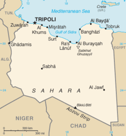
The Gulf of Sidra (Arabic: خليج السدرة, romanized: Khalij as-Sidra, also known as the Gulf of Sirte (Arabic: خليج سرت, romanized: Khalij Surt, is a body of water in the Mediterranean Sea on the northern coast of Libya, named after the oil port of Sidra or the city of Sirte.[2] It was also historically known as the Great Sirte or Greater Syrtis (Latin: Syrtis Major; Ancient Greek: Σύρτις μεγάλη; contrasting with Syrtis Minor on the coast of Tunisia).[3]
- ^ GoogleEarth
- ^ نبدة عن مدينة سرت – ليبيا Archived 2018-06-24 at the Wayback Machine (City of Sirte – Libya)
- ^ Cite error: The named reference
SMwas invoked but never defined (see the help page).
© MMXXIII Rich X Search. We shall prevail. All rights reserved. Rich X Search
