Back Bay Ridge (Brooklyn) German Bay Ridge (Brooklyn) Spanish Bay Ridge French Bay Ridge Italian Bay Ridge NB Бей-Ридж Russian 灣脊 Chinese
Bay Ridge | |
|---|---|
 | |
 Location in New York City | |
| Coordinates: 40°37′26″N 74°01′55″W / 40.624°N 74.032°W | |
| Country | |
| State | |
| City | |
| Borough | |
| Community District | Brooklyn 10[1] |
| Government | |
| • Congress | Dan Goldman (10th) Nicole Malliotakis (11th) |
| Area | |
| • Total | 2.12 sq mi (5.49 km2) |
| • Land | 2.12 sq mi (5.49 km2) |
| • Water | 0 sq mi (0 km2) |
| Population | |
| • Total | 79,371 |
| • Density | 37,000/sq mi (14,000/km2) |
| Time zone | UTC−5 (Eastern) |
| • Summer (DST) | UTC−4 (EDT) |
| ZIP Codes | 11209, 11220 |
| Area code | 718, 347, 929, and 917 |
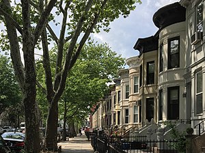
Bay Ridge is a neighborhood in the southwest corner of the New York City borough of Brooklyn. It is bounded by Sunset Park to the north, Dyker Heights to the east, the Narrows and the Belt Parkway to the west, and Fort Hamilton Army Base and the Verrazzano-Narrows Bridge to the south. The section of Bay Ridge south of 86th Street is sometimes considered part of a sub-neighborhood called Fort Hamilton.
Bay Ridge was formerly the westernmost portion of the town of New Utrecht, comprising two smaller villages: Yellow Hook to the north and Fort Hamilton to the south. Yellow Hook was named for the color of the soil and was renamed Bay Ridge in December 1853 to avoid negative connotations with yellow fever at the time; the name Bay Ridge was chosen based on the local geography.[4] Bay Ridge became developed as a rural summer resort during the mid-19th century. The arrival of the New York City Subway's Fourth Avenue Line (present-day R train) in 1916 led to its development as a residential neighborhood. Until the early 1970s, Bay Ridge was dominated by its Norwegian community, but by the late 20th and early 21st centuries, it had a large Arab, Irish, Italian, and Greek population.
Bay Ridge is part of Brooklyn Community District 10, and its primary ZIP Codes are 11209 and 11220.[1] It is patrolled by the 68th Precinct of the New York City Police Department.[5] Politically, it is represented by the New York City Council's 43rd District.[6]
- ^ a b "NYC Planning | Community Profiles". communityprofiles.planning.nyc.gov. New York City Department of City Planning. Retrieved March 18, 2019.
- ^ Census Shapefile for 2014 Zip Code Tabulation Areas Archived March 29, 2019, at the Wayback Machine Area of 11209 Zip Code Tabulation Area
- ^ Cite error: The named reference
PLP5was invoked but never defined (see the help page). - ^ "F.Y.I." Archived February 24, 2022, at the Wayback Machine, The New York Times, December 17, 1995. Accessed February 23, 2022. "More than a century ago, the area now known as Bay Ridge was called Yellow Hook, according to documents from the Bay Ridge Historical Society. The name referred to the yellow sand and clay in the soil. But yellow fever swept through the area in 1848-49, and the name Yellow Hook suddenly lost its charm.... So in December 1853, many of the large landowners from the area met to change the name. A florist named James Weir put forth the name Bay Ridge as one that suggested the 'geographic nature' of the land."
- ^ Cite error: The named reference
NYPD 68th Precinctwas invoked but never defined (see the help page). - ^ Current City Council Districts for Kings County Archived January 31, 2017, at the Wayback Machine, New York City. Accessed May 5, 2017.
© MMXXIII Rich X Search. We shall prevail. All rights reserved. Rich X Search