Back Морска карта (Скандинавия) Bulgarian Carta marina Czech Carta Marina Danish Carta Marina German Carta Marina Spanish Carta marina Estonian Carta marina Finnish Carta Marina French כרטא מרינה HE Carta Marina Hungarian
| Carta marina et descriptio septemtrionalium terrarium (Latin) English: Marine map and description of the Northern lands | |
|---|---|
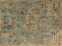
 Composite from 1949 facsimile |
Carta marina et descriptio septemtrionalium terrarum (Latin for Marine map and description of the Northern lands;[1] commonly abbreviated Carta marina) is the first map of the Nordic countries to give details and place names, created by Swedish ecclesiastic Olaus Magnus and initially published in 1539. Only two earlier maps of the Nordic countries are known, those of Jacob Ziegler (Strasbourg, 1532) and Claudius Clavus (15th century).
The map is centered on Scandia, which is shown in the largest size text on the map and placed on the middle of Sweden. The map covers the Nordic lands of "Svecia" (Svealand) and "Gothia" (Götaland) (both areas in Sweden), "Norvegia" (Norway), Dania (Denmark), Islandia (Iceland), Finlandia (Finland), Lituania (Lithuania) and Livonia (Estonia and Latvia). The map is framed with longitudes and latitudes running from 55° to the Arctic Circle.[2]
The 1.70 m wide by 1.25 m tall map was printed in black and white from nine 55x40 cm woodcut blocks sequenced from west to east and north to south and identified in the center with the letters A through I.[3]
- ^ "Carta Marina". Olaus Magnus' Scandinavia. University of Minnesota. Retrieved 10 June 2016.
- ^ Kleim, Uwe (1989). "Ein Kartenwerk der Nordlande vom Jahre 1539". Archived from the original on 1 July 2016. Retrieved 9 June 2016.
- ^ Kaiser, Reinhard. "Der Anfang - Glücklicher Zufall". Reinhard Kaisers Elektroarchiv (in German). Reinhard Kaiser. Retrieved 10 June 2016.
© MMXXIII Rich X Search. We shall prevail. All rights reserved. Rich X Search