Back تلال شفيوت ARZ Чевиот Хилс Bulgarian The Cheviot Hills CEB Cheviotské pohoří Czech Bryniau Cheviot Welsh Cheviot Hills German Montes Cheviot Spanish Monts Cheviot French Monaidhean Tìbhiot Irish Monaidhean Tìbhiot Scots/Gaelic
| Cheviot Hills | |
|---|---|
 The Cheviot and Coldburn Hill | |
| Highest point | |
| Peak | The Cheviot |
| Elevation | 815 m (2,674 ft) |
| Coordinates | 55°28′41″N 2°09′07″W / 55.478°N 2.152°W |
| Geography | |
Location in Northumberland | |
| Location | Northumberland, England |
| OS grid | NT905205 |
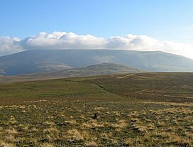
The Cheviot Hills (/ˈtʃiːviət/), or sometimes The Cheviots, are a range of uplands straddling the Anglo-Scottish border between Northumberland and the Scottish Borders. The English section is within the Northumberland National Park. The range includes The Cheviot (the highest hill), plus Hedgehope Hill to the east, Windy Gyle to the west, and Cushat Law and Bloodybush Edge to the south.
The hills are sometimes considered a part of the Southern Uplands of Scotland as they adjoin the uplands to the north. Since the Pennine Way runs through the region, the hills are also considered a part of the northern Pennines although they are separated from the Cheviot Hills by the Tyne Gap, part of which lies within the southern extent of the Northumberland National Park.[1][2]
The Cheviot Hills are primarily associated with geological activity from approximately 480 to 360 million years ago, when the continents of Avalonia and Laurentia collided, resulting in extensive volcanic activity (the Caledonian orogeny) which created a granite outcrop surrounded by lava flows.
The area enjoys a general right to roam under both the English Countryside and Rights of Way Act 2000 and the Scottish Land Reform (Scotland) Act 2003.
The Southern Cheviots include the Otterburn Training Area, the UK's largest firing range, where the Ministry of Defence train up to 30,000 soldiers a year.
- ^ "The Cheviots". My Pennines. My Pennines. Retrieved 25 October 2016.
- ^ Ogilvie, Alan Grant (1930). "Great Britain: Essays in Regional Geography". Google Books. Retrieved 25 October 2016.
© MMXXIII Rich X Search. We shall prevail. All rights reserved. Rich X Search
