Back Tree Map German Treemap French Treemap Italian Mapa drzewa Polish Treemapping Portuguese 矩形式树状结构绘图法 Chinese

In information visualization and computing, treemapping is a method for displaying hierarchical data using nested figures, usually rectangles.
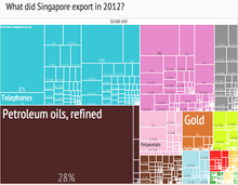
Treemaps display hierarchical (tree-structured) data as a set of nested rectangles. Each branch of the tree is given a rectangle, which is then tiled with smaller rectangles representing sub-branches. A leaf node's rectangle has an area proportional to a specified dimension of the data.[1] Often the leaf nodes are colored to show a separate dimension of the data.
When the color and size dimensions are correlated in some way with the tree structure, one can often easily see patterns that would be difficult to spot in other ways, such as whether a certain color is particularly relevant. A second advantage of treemaps is that, by construction, they make efficient use of space. As a result, they can legibly display thousands of items on the screen simultaneously.
- ^ Li, Rita Yi Man; Chau, Kwong Wing; Zeng, Frankie Fanjie (2019). "Ranking of Risks for Existing and New Building Works". Sustainability. 11 (10): 2863. doi:10.3390/su11102863.
© MMXXIII Rich X Search. We shall prevail. All rights reserved. Rich X Search