Back Burrard Inlet Czech Burrard Inlet German Burrard Inlet Spanish خلیجک بورارد Persian Burrard Inlet Finnish Baie Burrard French Burrardynham Frisian Burrard Inlet Italian バラード入り江 Japanese Burrard Polish
| Burrard Inlet | |
|---|---|
| səl̓ilw̓ət (Halkomelem) | |
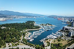
 Aerial view of Burrard Inlet | |
 Map of Burrard Inlet | |
| Location | Greater Vancouver, British Columbia, Canada |
| Coordinates | 49°17′55″N 123°05′07″W / 49.29861°N 123.08528°W |
| Type | Fjord |
| Part of | Salish Sea |
| Max. length | 44 km (27 mi) |
| Sections/sub-basins | English Bay, False Creek, Indian Arm |
Burrard Inlet (Halkomelem: səl̓ilw̓ət) is a shallow-sided fjord in the northwestern Lower Mainland, British Columbia, Canada.[1][2] Formed during the last Ice Age, it separates the City of Vancouver and the rest of the lowland Burrard Peninsula to the south from the coastal slopes of the North Shore Mountains, which span West Vancouver and the City and District of North Vancouver to the north.
Burrard Inlet opens west into the Strait of Georgia between Point Atkinson and Point Grey. Vancouver's Downtown Peninsula protrudes northwesterly into the inlet, separating it into the wide outer Burrard Inlet to the west and the elongated inner Burrard Inlet to the east. The southeastern portion of the outer inlet is an open bay known as English Bay, which has a narrow eastern inlet called False Creek. The 400-metre-wide (1,300 ft) strait between Prospect Point and the sandbanks just east of the Capilano River mouth, which connects the inlet's outer and inner sections, is known as the First Narrows, traversed by the Lions Gate Bridge. The inner inlet then widens into Vancouver Harbour, which hosts the Port of Vancouver, Canada's largest port.
At the eastern end of the harbour, Burrard Inlet narrows again into a 350-metre-wide (1,150 ft) strait between Burnaby Heights and the mouth of the Seymour River, known as the Second Narrows, which is traversed by the Ironworkers Memorial Bridge and the Second Narrows Rail Bridge. After the Second Narrows, it widens again and continues east until the headland near Dollarton, where it splits into two arms. The longer arm, known as Indian Arm, extends northerly between Mount Seymour and Eagle Mountain until it meets the deltas of Indian River mouth. The shorter arm, known as Port Moody Arm or Moody Inlet, courses further east for another 6 kilometres (3.7 mi) past a 320-metre-wide (1,050 ft) strait (traversed only by overhead powerlines) between Burnaby Mountain and the bluffs of Belcarra Regional Park. Port Moody Arm is almost completely encompassed by the City of Port Moody.
- ^ "Burrard Inlet". Geographical Names Data Base. Natural Resources Canada. Retrieved 2020-06-16.
- ^ "səl̓ilw̓ət (Sleilwaut) - Burrard Inlet/Indian Arm (Tsleil-Waututh) - The Bill Reid Centre - Simon Fraser University". www.sfu.ca. Retrieved 12 June 2021.
© MMXXIII Rich X Search. We shall prevail. All rights reserved. Rich X Search
