Back نهر ستينا Arabic Цетина Bulgarian Cetina BS Cetina (suba) CEB Cetina Czech Cetina Danish Cetina German Τσέτινα Greek Río Cetina Spanish Cetina ibaia Basque
| Cetina | |
|---|---|
 Cetina flows through rocky, karst terrain. | |
 | |
| Location | |
| Country | Croatia |
| Physical characteristics | |
| Source | |
| • location | Dinara |
| Mouth | |
• location | Adriatic Sea |
• coordinates | 43°26′23″N 16°41′11″E / 43.4398°N 16.6864°E |
| Length | 101 km (63 mi)[1] |
| Basin size | 1,463 km2 (565 sq mi)[1] |
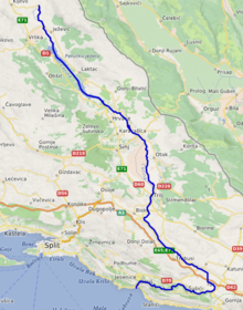
Cetina (pronounced [tsětina]) is a river in southern Croatia. It has a length of 101 km (63 mi) and its basin covers an area of 1,463 km2 (565 sq mi).[1] From its source, Cetina descends from an elevation of 385 metres (1,263 ft) above sea level to the Adriatic Sea. It is the most water-rich river in Dalmatia.[2]
- ^ a b c Statistical Yearbook of the Republic of Croatia 2017 (PDF) (in Croatian and English). Zagreb: Croatian Bureau of Statistics. December 2017. p. 47. ISSN 1333-3305. Archived from the original (PDF) on 13 November 2018. Retrieved 23 May 2018.
- ^ Naklada Naprijed, The Croatian Adriatic Tourist Guide, pg. 258, Zagreb (1999), ISBN 953-178-097-8
© MMXXIII Rich X Search. We shall prevail. All rights reserved. Rich X Search