Back Кориско (остров) Bulgarian Corisco Catalan Isla de Corisco CEB Corisco German Isla Corisco (Guinea Ecuatorial) Spanish Corisco Basque Corisco French Corisco Hausa Corisco (otok) Croatian Corisco (isola) Italian
| Disputed island | |
|---|---|
 | |
 Corisco Island and Elobey Islands | |
| Geography | |
| Coordinates | 0°54′54″N 9°19′12″E / 0.91500°N 9.32000°E |
| Area | 14 km2 (5.4 sq mi) |
| Length | 6 km (3.7 mi) |
| Width | 5 km (3.1 mi) |
| Highest point | 35 m |
| Administration | |
| Litoral | |
| Insular Region | |
| Claimed by | |
| Additional information | |
| Time zone | |
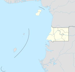
Corisco, Mandj, or Mandyi,[1] is a small island of Equatorial Guinea, located 29 km (18 mi) southwest of the Río Muni estuary that defines the border with Gabon. Corisco, whose name derives from the Portuguese word for lightning, has an area of 14 km2 (5 sq mi), and its highest point is 35 m (115 ft) above sea level. The most important settlement on the island is Gobe.
- ^ "Isla de Corsico | Marine World Database". 2015-05-11. Archived from the original on 2015-05-11. Retrieved 2022-08-01.
{{cite web}}: CS1 maint: bot: original URL status unknown (link)
© MMXXIII Rich X Search. We shall prevail. All rights reserved. Rich X Search
