Back Don Afrikaans ዶን ወንዝ Amharic Danais ANG نهر الدون Arabic نهر الدون ARZ Ríu Don AST Don çayı Azerbaijani دون چایی AZB Дон Bashkir Дон Byelorussian
| Don | |
|---|---|
 The Don in Voronezh Oblast. | |
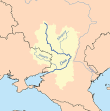
 Catchment of the Don | |
| Native name | Дон (Russian) |
| Location | |
| Country | |
| Region | |
| Cities | Voronezh, Rostov-on-Don |
| Physical characteristics | |
| Source | |
| • location | Novomoskovsk, Tula Oblast |
| • coordinates | 54°00′43″N 38°16′41″E / 54.01194°N 38.27806°E |
| • elevation | 238 m (781 ft) |
| Mouth | Sea of Azov |
• location | Kagal'nik, Rostov Oblast |
• coordinates | 47°05′11″N 39°14′19″E / 47.08639°N 39.23861°E |
• elevation | 0 m (0 ft) |
| Length | 1,870 km (1,160 mi) |
| Basin size | 425,600 km2 (164,300 sq mi) |
| Discharge | |
| • average | 935 m3/s (33,000 cu ft/s) |
| Basin features | |
| Tributaries | |
| • left | Khopyor |
| • right | Seversky Donets |
The Don (Russian: Дон) is the fifth-longest river in Europe. Flowing from Central Russia to the Sea of Azov in Southern Russia, it is one of Russia's largest rivers and played an important role for traders from the Byzantine Empire.
Its basin is between the Dnieper basin to the west, the lower Volga basin immediately to the east, and the Oka basin (tributary of the Volga) to the north. Native to much of the basin were Slavic nomads.[1]
The Don rises in the town of Novomoskovsk 60 kilometres (37 mi) southeast of Tula (in turn 193 kilometres (120 mi) south of Moscow), and flows 1,870 kilometres to the Sea of Azov. The river's upper half ribbles (meanders subtly) south; however, its lower half consists of a great eastern curve, including Voronezh, making its final stretch, an estuary, run west south-west. The main city on the river is Rostov-on-Don. Its main tributary is the Seversky Donets, centred on the mid-eastern end of Ukraine, thus the other country in the overall basin. To the east of a series of three great ship locks and associated ponds is the 101-kilometre (63 mi) Volga–Don Canal.
© MMXXIII Rich X Search. We shall prevail. All rights reserved. Rich X Search