Back Eubea Afrikaans Euböa ALS وابية Arabic وابيه ARZ Evbeya Azerbaijani Эўбея Byelorussian Эўбэя BE-X-OLD Евбея Bulgarian Euboia Breton Eubea Catalan
Native name: Εύβοια | |
|---|---|
 NASA picture of Central Greece with Euboea lying to the right | |
 | |
| Geography | |
| Coordinates | 38°30′N 24°00′E / 38.500°N 24.000°E |
| Archipelago | Aegean Islands |
| Area | 3,684 km2 (1,422 sq mi) |
| Highest elevation | 1,743 m (5719 ft) |
| Highest point | Dirfi |
| Administration | |
| Region | Central Greece |
| Regional unit | Euboea |
| Municipality | Εύβοια |
| Capital city | Chalcis |
| Demographics | |
| Population | 191,206 (2011) |
| Pop. density | 54/km2 (140/sq mi) |
| Additional information | |
| Postal code | 34x xx |
| Area code(s) | 22x0 |
| Vehicle registration | XA |
| Official website | www.naevias.gr |
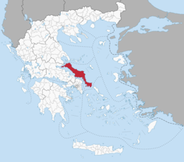
Euboea (/juːˈbiːə/, yoo-BEE-ə; Greek: Εὔβοια Eúboia, Ancient: [ěu̯boi̯a], Modern: [ˈevia]) also known by its modern spelling Evia (/ˈɛviə/, EH-vee-ə), is the second-largest Greek island in area and population, after Crete, and the sixth largest island in the Mediterranean Sea. It is separated from Boeotia in mainland Greece by the narrow Euripus Strait (only 40 m (130 ft) at its narrowest point).[1] In general outline it is a long and narrow island; it is about 180 km (110 mi) long, and varies in breadth from 50 km (31 mi) to 6 km (3.7 mi). Its geographic orientation is from northwest to southeast, and it is traversed throughout its length by a mountain range, which forms part of the chain that bounds Thessaly on the east, and is continued south of Euboia in the lofty islands of Andros, Tinos and Mykonos.[2]
It forms most of the regional unit of Euboea, which also includes Skyros and a small area of the Greek mainland.
- ^ "Euripus | strait, Greece". Encyclopedia Britannica. Retrieved 2018-08-20.
- ^ Tozer 1911, p. 865.
© MMXXIII Rich X Search. We shall prevail. All rights reserved. Rich X Search