Back جغرافيا بوروندي Arabic Xeografía de Burundi AST Геаграфія Бурундзі Byelorussian География на Бурунди Bulgarian Γεωγραφία του Μπουρούντι Greek Geografía de Burundi Spanish جغرافیای بوروندی Persian Géographie du Burundi French Ọdịdị ala nke Burundi IG Geografia del Burundi Italian
This article needs additional citations for verification. (February 2013) |
  | |
| Continent | Africa[1] |
|---|---|
| Region | East Africa |
| Coordinates | 3°30′S 30°0′E / 3.500°S 30.000°E |
| Area | Ranked 142nd |
| • Total | 27,830 km2 (10,750 sq mi) |
| • Land | 92.2% |
| • Water | 7.8% |
| Coastline | 0 km (0 mi) |
| Borders | 1,140 km (DRC 236 km, Rwanda 315 km, Tanzania 589 km) |
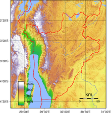
| Highest point | Mount Heha 2684 m |
| Lowest point | Lake Tanganyika 772 m |
| Longest river | Ruvubu 300 km |
| Largest lake | Lake Tanganyika |


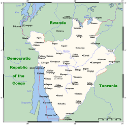
Burundi is located in East Africa, to the east of the Democratic Republic of the Congo, at the coordinates 3°30′S 30°0′E / 3.500°S 30.000°E.
- ^ "CIA World Factbook". 15 November 2022.
© MMXXIII Rich X Search. We shall prevail. All rights reserved. Rich X Search