Back جغرافيا منغوليا Arabic Xeografía de Mongolia AST Monqolustan coğrafiyası Azerbaijani Геаграфія Манголіі Byelorussian География на Монголия Bulgarian মঙ্গোলিয়া#ভূগোল Bengali/Bangla جوگرافیای مەنگۆلیا CKB Geografie Mongolska Czech Geographie der Mongolei German Geografía de Mongolia Spanish
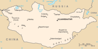
 Map showing the major cities and the neighbouring countries of Mongolia | |
| Continent | Asia |
|---|---|
| Region | East Asia |
| Coordinates | 46°0′N 105°0′E / 46.000°N 105.000°E |
| Area | Ranked 18 |
| • Total | 1,564,116[1] km2 (603,909 sq mi) |
| • Land | 99.3% |
| • Water | 0.7% |
| Borders | Russia: 3,485 kilometres (2,165 mi) China: 4,676 kilometres (2,906 mi) |
| Highest point | Khüiten Peak 4,374 m (14,350 ft) |
| Lowest point | Hoh Nuur 560 m (1,840 ft) |
| Longest river | Orkhon River 1,124 kilometres (698 mi) |
| Largest lake | Uvs Lake by area: 3,350 km2 (1,290 sq mi) Khövsgöl Nuur by volume: 480.7 km3 (115.3 cu mi) |
| Climate | Desert; continental |
| Terrain | Vast semidesert and desert plains, grassy steppe, mountains in west and southwest |
| Natural resources | Oil, coal, copper, molybdenum, tungsten, phosphates, tin, nickel, zinc, fluorspar, gold, silver, iron |
| Natural hazards | Dust storms; grassland and forest fires; drought |
| Environmental issues | Limited natural freshwater; the burning of soft coal for power; poor enforcement of environmental laws; severe air pollution in Ulaanbaatar; deforestation, overgrazing, soil erosion; desertification and poor mining practise |
Mongolia is a landlocked country in East Asia, located between China and Russia. The terrain is one of mountains and rolling plateaus, with a high degree of relief.[2] The total land area of Mongolia is 1,564,116 square kilometres.[3] Overall, the land slopes from the high Altai Mountains of the west and the north to plains and depressions in the east and the south.[2] The Khüiten Peak in extreme western Mongolia on the Chinese border is the highest point (4,374 m (14,350 ft)).[2] The lowest point is at 560 m (1,840 ft), is the Hoh Nuur or lake Huh.[1] The country has an average elevation of 1,580 m (5,180 ft).[2]
The landscape includes one of Asia's largest freshwater lakes (Lake Khövsgöl), many salt lakes, marshes, sand dunes, rolling grasslands, alpine forests, and permanent mountain glaciers.[2] Northern and western Mongolia are seismically active zones, with frequent earthquakes and many hot springs and extinct volcanoes.[2] The nation's closest point to any ocean is approximately 645 kilometres (401 mi) from the country's easternmost tip, bordering North China to Jinzhou in Liaoning province, China along the coastline of the Bohai Sea.
- ^ a b
 This article incorporates public domain material from "Mongolia". The World Factbook (2024 ed.). CIA. 2022. (Archived 2022 edition.)
- ^ a b c d e f
 This article incorporates text from this source, which is in the public domain: DeGlopper, Donald R. (1991). "The Society and Its Environment". In Worden, Robert L.; Savada, Andrea Matles (eds.). Mongolia: a country study. Washington, D.C.: Federal Research Division, Library of Congress. OCLC 622910663.
- ^ "Population by sex, annual rate of population change, surface area and density" (PDF). United Nations Statistics Division. 2020. Retrieved February 12, 2022.
© MMXXIII Rich X Search. We shall prevail. All rights reserved. Rich X Search