Back جغرافيا تونس Arabic Xeografía de Tunicia AST Геаграфія Туніса Byelorussian География на Тунис Bulgarian Daearyddiaeth Tiwnisia Welsh Γεωγραφία της Τυνησίας Greek Geografía de Túnez Spanish جغرافیای تونس Persian Géographie de la Tunisie French Xeografía de Tunisia Galician
  | |
| Continent | Africa |
|---|---|
| Region | Northern Africa |
| Coordinates | 34°00′N 9°00′E / 34.000°N 9.000°E |
| Area | Ranked 93rd |
| • Total | 163,610 km2 (63,170 sq mi) |
| • Land | 95% |
| • Water | 5% |
| Coastline | 1,148 km (713 mi) |
| Borders | Total land borders: 1,424 km Algeria 965 km, Libya 459 km |
| Highest point | Jebel ech Chambi 1,544 m |
| Lowest point | Chott el Djerid -17 m |
| Longest river | Medjerda River 450 km |

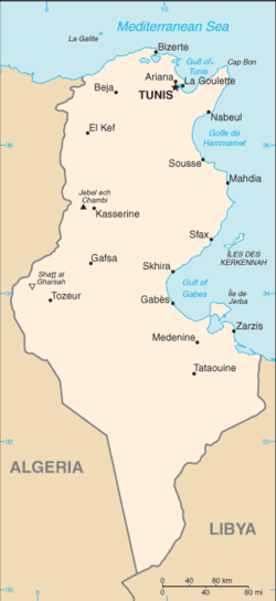
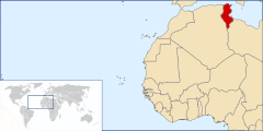
Tunisia is a country in Northern Africa, bordering the Mediterranean Sea, having a western border with Algeria (965 km) and south-eastern border with Libya (459 km) where the width of land tapers to the south-west into the Sahara. The country has north, east and complex east-to-north coasts including the curved Gulf of Gabès, which forms the western part of Africa's Gulf of Sidra. Most of this greater gulf forms the main coast of Libya including the city of Sirte which shares its root name. The country's geographic coordinates are 34°00′N 9°00′E / 34.000°N 9.000°E. Tunisia occupies an area of 163,610 square kilometres, of which 8,250 are water. The principal and reliable rivers rise in the north of the country with a few notable exceptions from north-east Algeria and flow through the northern plain where sufficient rainfall supports diverse plant cover and irrigated agriculture.
© MMXXIII Rich X Search. We shall prevail. All rights reserved. Rich X Search