Back جيولوجيا منطقة الكابيتول ريف Arabic Géologie de la région de Capitol Reef French Geologio dil areo di Capitol Reef IO


The exposed geology of the Capitol Reef area presents a record of mostly Mesozoic-aged sedimentation in an area of North America in and around Capitol Reef National Park, on the Colorado Plateau in southeastern Utah.
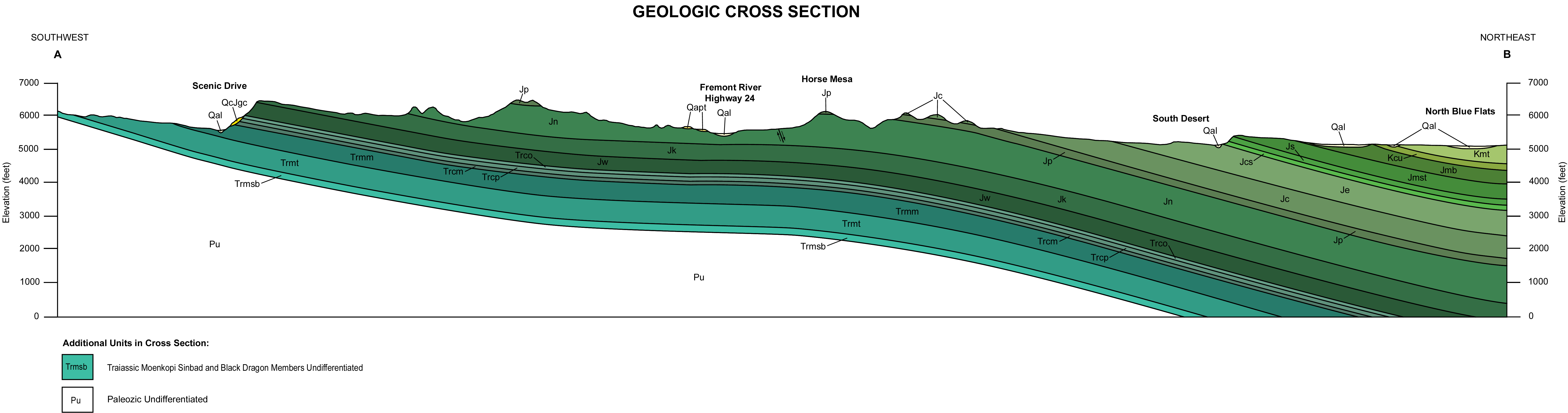
Nearly 10,000 feet (3,000 m) of sedimentary strata are found in the Capitol Reef area, representing nearly 200 million years of geologic history of the south-central part of the U.S. state of Utah. These rocks range in age from Permian (as old as 270 million years old) to Cretaceous (as young as 80 million years old.)[1] Rock layers in the area reveal ancient climates as varied as rivers and swamps (Chinle Formation), Sahara-like deserts (Navajo Sandstone), and shallow ocean (Mancos Shale).
The area's first known sediments were laid down as a shallow sea invaded the land in the Permian. At first sandstone was deposited but limestone followed as the sea deepened. After the sea retreated in the Triassic, streams deposited silt before the area was uplifted and underwent erosion. Conglomerate followed by logs, sand, mud and wind-transported volcanic ash were later added. Mid to Late Triassic time saw increasing aridity, during which vast amounts of sandstone were laid down along with some deposits from slow-moving streams. As another sea started to return, it periodically flooded the area and left evaporite deposits. Barrier islands, sand bars and later, tidal flats, contributed sand for sandstone, followed by cobbles for conglomerate, and mud for shale. The sea retreated, leaving streams, lakes and swampy plains to become the resting place for sediments. Another sea, the Western Interior Seaway, returned in the Cretaceous and left more sandstone and shale only to disappear in the early Cenozoic.
From 70 to 50 million years ago the Laramide orogeny, a major mountain building event in western North America, created the Rocky Mountains to the east. The uplift possibly acted on a buried fault to form the area's Waterpocket Fold. More recent uplift of the entire Colorado Plateau and the resulting erosion has exposed this fold at the surface only within the last 15 to 20 million years. Ice ages in the Pleistocene increased the rate of precipitation and erosion. The cracked upper parts of the Waterpocket Fold were especially affected and the fold itself was exposed and dissected.

- ^ NPS, "Capitol Reef"
© MMXXIII Rich X Search. We shall prevail. All rights reserved. Rich X Search