Back جبل هيرمانسكوجيل ARZ Hermannskogel CEB Hermannskogel Czech Hermannskogel Danish Hermannskogel German Hermannskogel French Hermannskogel Hungarian Hermannskogel LLD Херманнскогель Russian Hermannskogel Swedish
| Hermannskogel | |
|---|---|
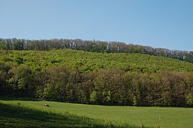
 Hermannskogel (and top of Habsburgwarte) seen from the Rohrerwiese | |
| Highest point | |
| Elevation | 542 m (1,778 ft) |
| Coordinates | 48°16′N 16°17′E / 48.267°N 16.283°E |
| Geography | |
The Hermannskogel (German pronunciation: [ˈhɛʁmansˌkoːɡl̩] ⓘ) is a hill in Döbling, the 19th district of Vienna. At 542 metres above sea level, it is the highest natural point of Vienna. It lies on the border to Lower Austria.
The Habsburgwarte, standing atop the Hermannskogel, marked the kilometre zero in cartographic measurements used in Austria-Hungary until 1918.
© MMXXIII Rich X Search. We shall prevail. All rights reserved. Rich X Search
