Back هوب (كولومبيا البريطانية) Arabic Hope (lungsod sa Kanada, British Columbia) CEB Hope (British Columbia) German Hope (Columbia Británica) Spanish Hope (Colombie-Britannique) French Hope (Columbia Britannica) Italian Hope (Brits-Columbia) Dutch Hope (Britisk Columbia) NB Hope, British Columbia SIMPLE Hope, British Columbia Swedish
Parts of this article (those related to Nestlé Waters has changed hands. Also, article mentions a second annual festival held several years ago. And could somebody please make this article sound less like a tourism department press release) need to be updated. (September 2021) |
Hope | |
|---|---|
| District of Hope[1] | |
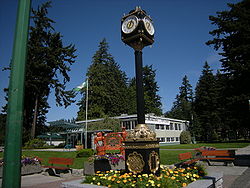
 Municipal building and street clock with Memorial Park in background | |
Location of Hope in British Columbia Location of Hope in Fraser Valley Regional District | |
| Coordinates: 49°23′09″N 121°26′31″W / 49.38583°N 121.44194°W | |
| Country | Canada |
| Province | British Columbia |
| Regional district | Fraser Valley |
| Established | 1848 |
| Government | |
| • Mayor | Victor A. Smith |
| Area | |
| • Total | 40.95 km2 (15.81 sq mi) |
| Elevation | 41 m (135 ft) |
| Population (2021) | |
| • Total | 6,686 |
| • Density | 151.0/km2 (391/sq mi) |
| Time zone | UTC-8 (Pacific Standard Time) |
| • Summer (DST) | UTC-7 (Pacific Daylight Time) |
| Area code | 604 / 778 / 236 |
| Highways | |
| Website | hope |
Hope is a district municipality at the confluence of the Fraser and Coquihalla rivers in the province of British Columbia, Canada. Hope is at the eastern end of both the Fraser Valley and the Lower Mainland region, and is at the southern end of the Fraser Canyon. To the east, over the Cascade Mountains, is the Interior region, beginning with the Similkameen Country on the farther side of the Allison Pass in Manning Park. Located 154 kilometres (96 mi) east of Vancouver, Hope is at the southern terminus of the Coquihalla Highway and the western terminus of the Crowsnest Highway, locally known as the Hope-Princeton (Highways 5 and 3, respectively), where they merge with the Trans-Canada Highway (Highway 1). Hope is at the eastern terminus of Highway 7. As it lies at the eastern end of the Fraser Valley in the windward Cascade foothills, the town gets very high amounts of rain and cloud cover – particularly throughout the autumn and winter.
Hope is a member municipality of the Fraser Valley Regional District which provides certain municipal services to unincorporated settlements and rural areas.
The District of Hope includes Hope[2] (the previous Town of Hope)[3] and surrounding areas, including the communities of Kawkawa Lake,[4] Silver Creek,[5] Flood, and Lake of the Woods.[6][7]
- ^ "British Columbia Regional Districts, Municipalities, Corporate Name, Date of Incorporation and Postal Address" (XLS). British Columbia Ministry of Communities, Sport and Cultural Development. Archived from the original on July 13, 2014. Retrieved November 2, 2014.
- ^ "Hope Townsite Roadmap" (PDF). hope.ca. Archived from the original (PDF) on October 27, 2011.
- ^ "Fraser Valley Regional District". Archived from the original on February 1, 2014.
- ^ "Kawkawa Lake Roadmap" (PDF). hope.ca. Archived from the original (PDF) on October 27, 2011.
- ^ "Silver Creek Roadmap" (PDF). hope.ca. Archived from the original (PDF) on October 27, 2011.
- ^ "Map of the District of Hope" (PDF). hope.ca. Archived from the original (PDF) on October 27, 2011.
- ^ "Hope BC". www.hope.ca. Archived from the original on July 18, 2012.
© MMXXIII Rich X Search. We shall prevail. All rights reserved. Rich X Search


