Back Howe Island (pulo sa Kanada, Ontario) CEB Howe Island German Howe Island Swedish Howe Adası Turkish
This article needs additional citations for verification. (December 2009) |
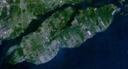
 NASA image | |
 | |
| Geography | |
|---|---|
| Location | St. Lawrence River |
| Coordinates | 44°16′13″N 76°17′1″W / 44.27028°N 76.28361°W |
| Archipelago | Thousand Islands |
| Area | 31 km2 (12 sq mi) |
| Administration | |
Canada | |
| Province | Ontario |
| County | Frontenac County |
| Township | Frontenac Islands |
| Demographics | |
| Population | 602 (2011) |
Howe Island is an island located in Lake Ontario east of Kingston in Frontenac County, Ontario, Canada. It is part of the Thousand Islands chain. Together with Wolfe Island and Simcoe Island, Howe Island is part of the township of Frontenac Islands, created through municipal amalgamation in 1998.
Howe Island measures 13 km (8 mi) long and 5 km (3 mi) wide and has an area of 31 km2 (12 mi2). It is the 2nd largest of the “Thousand Islands”. The main channel of the St. Lawrence River passes to the south of the island and merges with Lake Ontario, while the Bateau Channel passes on the north between the Canadian mainland and the island.
© MMXXIII Rich X Search. We shall prevail. All rights reserved. Rich X Search