Back Kermadec-eilande Afrikaans جزر كرماديك Arabic Кермадэк Byelorussian Кермадек (острови) Bulgarian Inizi Kermadeg Breton Illes Kermadec Catalan Kermadec Islands CEB Kermadekovy ostrovy Czech Kermadecinseln German Kermadekoj Esperanto
This article needs additional citations for verification. (December 2008) |
Rangitāhua | |
|---|---|
Location (in green rectangle) in the Pacific Ocean | |
 | |
| Geography | |
| Coordinates | 29°16′37″S 177°55′24″W / 29.27694°S 177.92333°W |
| Total islands | around 16 |
| Area | 33.6 km2 (13.0 sq mi) |
| Highest elevation | 516 m (1693 ft) |
| Administration | |
| Demographics | |
| Population | about 6[1] |
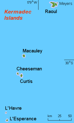
The Kermadec Islands (/ˈkɜːrmədɛk/ KUR-mə-dek; Māori: Rangitāhua)[2] are a subtropical island arc in the South Pacific Ocean 800–1,000 km (500–620 mi) northeast of New Zealand's North Island, and a similar distance southwest of Tonga. The islands are part of New Zealand. They are 33.6 km2 (13.0 sq mi)[3] in total area and uninhabited, except for the permanently staffed Raoul Island Station, the northernmost outpost of New Zealand.
The islands are listed with the New Zealand outlying islands. The islands are an immediate part of New Zealand, but not part of any region or district, but instead an Area Outside Territorial Authority.
- ^ "New Zealand Volcano Erupts". CBS News. 16 March 2006. Archived from the original on 18 June 2020. Retrieved 18 June 2020.
- ^ "Kermadec Islands". Te Ara – the Encyclopedia of New Zealand. Retrieved 1 November 2022.
- ^ "Data Table – Protected Areas – LINZ Data Service (recorded area 3359.9864 ha)". Land Information New Zealand. Retrieved 27 August 2019.
© MMXXIII Rich X Search. We shall prevail. All rights reserved. Rich X Search