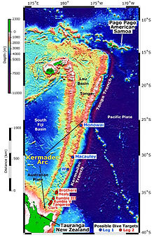
The Lau Basin is a back-arc basin (also addressed as "interarc basin"[1]) at the Australian-Pacific plate boundary. It is formed by the Pacific plate subducting under the Australian plate. The Tonga-Kermadec Ridge, a frontal arc, and the Lau-Colville Ridge, a remnant arc, sit to the eastern and western sides of the basin, respectively.[2] The basin has a raised transition area to the south where it joins the Havre Trough.
- ^ Karig, D. E. (1970). "Ridges and basins of the Tonga-Kermadec island arc system". Journal of Geophysical Research. 75 (2): 239–254. Bibcode:1970JGR....75..239K. doi:10.1029/JB075i002p00239.
- ^ Gill, J. B. 1976. "Composition and Age of Lau Basin and Ridge Volcanic Rocks: Implications for Evolution of an Interarc Basin and Remnant Arc." Bulletin of the Geological Society of America 87 (10): 1384–1395.
© MMXXIII Rich X Search. We shall prevail. All rights reserved. Rich X Search

