Back جبل مونت جاريبالدى ARZ Dalton Dome CEB Mount Garibaldi German Monte Garibaldi Spanish کوه گریبالدی Persian Mont Garibaldi French Mount Garibaldi Icelandic Monte Garibaldi Italian 가리발디산 Korean Mount Garibaldi LLD
| Mount Garibaldi | |
|---|---|
| Nch'ḵay̓ | |
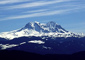
 West face of Mount Garibaldi | |
| Highest point | |
| Elevation | 2,678 m (8,786 ft)[1] |
| Coordinates | 49°51′01″N 123°00′17″W / 49.85028°N 123.00472°W[2] |
| Dimensions | |
| Length | 3 km (1.9 mi)[3] |
| Width | 5 km (3.1 mi)[3] |
| Volume | 6.5 km3 (1.6 cu mi)[3] |
| Naming | |
| Etymology | Giuseppe Garibaldi[2] |
| Native name | Nch'ḵay̓ (Squamish)[2] |
| Geography | |
| Country | Canada[3] |
| Province | British Columbia[3] |
| District | New Westminster Land District[2] |
| Protected area | Garibaldi Provincial Park[4] |
| Parent range | Garibaldi Ranges |
| Topo map | NTS 92G14 Cheakamus River[2] |
| Geology | |
| Age of rock | < 260,000 years old[3] |
| Mountain type | Stratovolcano[1] |
| Type of rock | Dacite[3] |
| Volcanic arc/belt | Cascade Volcanic Arc[5] Garibaldi Volcanic Belt[3] |
| Last eruption | 8060 BCE ± 500 years[6] |
Mount Garibaldi (known as Nch'ḵay̓, IPA: [n̩.ʧʼqɛˀj̰], to the indigenous Squamish people) is a dormant stratovolcano in the Garibaldi Ranges of the Pacific Ranges in southwestern British Columbia, Canada. It has a maximum elevation of 2,678 metres (8,786 feet) and rises above the surrounding landscape on the east side of the Cheakamus River in New Westminster Land District. In addition to the main peak, Mount Garibaldi has two named sub-peaks. Atwell Peak is a sharp, conical peak slightly higher than the more rounded peak of Dalton Dome. Both were volcanically active at different times throughout Mount Garibaldi's eruptive history. The northern and eastern flanks of Mount Garibaldi are obscured by the Garibaldi Névé, a large snowfield containing several radiating glaciers. Flowing from the steep western face of Mount Garibaldi is the Cheekye River, a tributary of the Cheakamus River. Opal Cone on the southeastern flank is a small volcanic cone from which a lengthy lava flow descends. The western face is a landslide feature that formed in a series of collapses between 12,800 and 11,500 years ago. These collapses resulted in the formation of a large debris flow deposit that fans out into the Squamish Valley.
Mount Garibaldi has been the focus of intermittent volcanic activity over the last 260,000 years. This activity produced mostly dacite, the main type of volcanic rock forming Mount Garibaldi. Volcanism between 260,000 and 220,000 years ago constructed an ancestral cone that was subsequently destroyed. Another growth period began with the eruption of Atwell Peak about 13,000 years ago when Mount Garibaldi was surrounded by an ice sheet during the last glacial period. The latest period of volcanic activity took place about 10,000 years ago with eruptions from Dalton Dome and Opal Cone after the ice sheet retreated. Although the mountain is not known to have been volcanically active since that time, it could erupt again, which could endanger the nearby populace. If this were to happen, relief efforts could be organized by teams such as the Interagency Volcanic Event Notification Plan who are prepared to notify people threatened by volcanic eruptions in Canada.
The area surrounding Mount Garibaldi has been inhabited by indigenous peoples for thousands of years. Their oral history includes a story of the mountain and a great flood. The non-indigenous name of the mountain was given by George Henry Richards in 1860 in honour of the Italian patriot and soldier Giuseppe Garibaldi. Several mountaineers had climbed Mount Garibaldi by the early 1900s, some of whom were members of mountaineering clubs. A plane operated by Pacific Western Airlines crashed on the slopes of Mount Garibaldi in 1953; all five people aboard were killed. The construction of a ski resort was begun in the late 1960s, but developments were halted in 1969 due to financial difficulties. Several climbing routes ascend the flanks of Mount Garibaldi and involve traversing glaciers, snow slopes or loose rock. Mountain climbing hazards include crevasses, avalanches and rockfalls. Access to Mount Garibaldi is via hiking trails from Alice Ridge, Brohm Ridge, and the Diamond Head parking lot at the end of Garibaldi Park Road.
- ^ a b "Garibaldi: General Information". Global Volcanism Program. Smithsonian Institution. Archived from the original on 2022-01-09. Retrieved 2022-04-03.
- ^ a b c d e "Mount Garibaldi". BC Geographical Names. Archived from the original on 2022-01-09. Retrieved 2022-04-03.
- ^ a b c d e f g h Wood, Charles A.; Kienle, Jürgen (1990). Volcanoes of North America: United States and Canada. Cambridge University Press. pp. 112, 113, 114, 144, 145. ISBN 0-521-43811-X.
- ^ "Garibaldi Provincial Park". BC Parks. Archived from the original on 2021-07-16. Retrieved 2010-06-20.
- ^ Wilson, A. M.; Russell, J. K. (2019). "Quaternary glaciovolcanism in the Canadian Cascade volcanic arc—Paleoenvironmental implications". Field Volcanology: A Tribute to the Distinguished Career of Don Swanson. Vol. 538. Geological Society of America. pp. 134, 141. doi:10.1130/SPE538. ISBN 978-0-8137-9538-6. S2CID 214521258.
- ^ "Garibaldi: Eruptive History". Global Volcanism Program. Smithsonian Institution. Archived from the original on 2022-01-09. Retrieved 2022-04-03.
© MMXXIII Rich X Search. We shall prevail. All rights reserved. Rich X Search
