Back Lanyu adası Azerbaijani Isla nin Orchid BCL Lan Yu (pulo) CEB Orchidejový ostrov Czech Lan Yu (Insel) German Isla de las Orquídeas (Taiwán) Spanish Lanyu Finnish Lanyu French Làn-yí HAK Isla ti Orkidia ILO
Native name: Pongso no Tao | |
|---|---|
 | |
Orchid Island in Taiwan | |
| Geography | |
| Location | Philippine Sea |
| Coordinates | 22°03′N 121°32′E / 22.050°N 121.533°E |
| Area | 45 km2 (17 sq mi) |
| Highest elevation | 552 m (1811 ft) |
| Highest point | Mount Hongtou |
| Administration | |
Republic of China | |
| Township | Lanyu |
| County | Taitung |
| Province | Taiwan (streamlined, government dissolved) |
| Demographics | |
| Population | 5,255 (February 2023) |
| Ethnic groups | Tao, Han |
| Orchid Island | |||||||||||||||||||
|---|---|---|---|---|---|---|---|---|---|---|---|---|---|---|---|---|---|---|---|
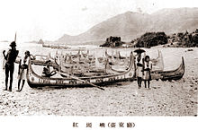
 The shore of Orchid Island from an imperial Japanese publication (c. 1931) | |||||||||||||||||||
| Traditional Chinese | 蘭嶼 | ||||||||||||||||||
| Literal meaning | Orchid Islet(s) | ||||||||||||||||||
| |||||||||||||||||||
| Former names | |||||||||||||||||||
|---|---|---|---|---|---|---|---|---|---|---|---|---|---|---|---|---|---|---|---|
 | |||||||||||||||||||
| Chinese name | |||||||||||||||||||
| Traditional Chinese | 紅頭嶼 | ||||||||||||||||||
| Literal meaning | |||||||||||||||||||
| |||||||||||||||||||
| Japanese name | |||||||||||||||||||
| Kanji | 紅頭嶼 | ||||||||||||||||||
| Hiragana | こうとうしょ | ||||||||||||||||||
| Katakana | コウトウショ | ||||||||||||||||||
| |||||||||||||||||||
| Lesser Orchid Island | |||||||||||||||
|---|---|---|---|---|---|---|---|---|---|---|---|---|---|---|---|
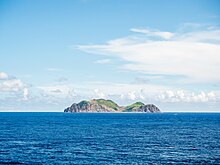
 Lesser Orchid Island | |||||||||||||||
| Traditional Chinese | 小蘭嶼 | ||||||||||||||
| Literal meaning | Little Orchid Islet | ||||||||||||||
| |||||||||||||||
Orchid Island,[2] also known by other names, is a 45 km2 (17 sq mi) volcanic island off the southeastern coast of Taiwan, which Orchid Island is part of. It is separated from the Batanes of the Philippines by the Bashi Channel of the Luzon Strait. The island and the nearby Lesser Orchid Island are governed as Lanyu Township in Taitung County, which is one of the county's two insular townships (the other being Lyudao Township).
- ^ Stöpel, Karl Theodor (1905). Eine Reise in das Innere der Insel Formosa (in German).
- ^ RICK CHARETTE (November 2019). "Surf and Turf With Indigenous Influences". Travel in Taiwan. Tourism Bureau, MOTC. p. 39.
Orchid Island (Lanyu) 蘭嶼
© MMXXIII Rich X Search. We shall prevail. All rights reserved. Rich X Search
