Back راين القديم (أوترخت وجنوب هولندا) Arabic راين القديم ARZ Аўдэ-Рэйн Byelorussian Стары Райн BE-X-OLD Ауде-Рейн CV Oude Rijn Welsh Oude Rijn German Oude Rijn Estonian Vieux Rhin French Alde Ryn Frisian
| Oude Rijn Old Rhine | |
|---|---|
 The Oude Rijn in Leiden | |
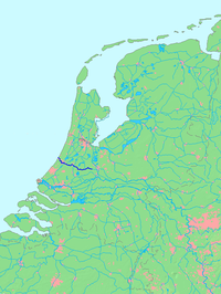
 Location of Oude Rijn in dark blue. | |
| Location | |
| Country | Netherlands |
| Region | Utrecht, South Holland |
| Physical characteristics | |
| Source | Leidse Rijn |
| • location | Harmelen, Utrecht |
| • coordinates | 52°05′31.5″N 4°57′48.5″E / 52.092083°N 4.963472°E |
| Mouth | North Sea |
• location | Katwijk, South Holland |
• coordinates | 52°12′43″N 4°23′54″E / 52.21194°N 4.39833°E |
| Length | 52 km (32 mi) |
The Oude Rijn ("Old Rhine") is a branch of the Rhine delta in the Dutch provinces of Utrecht and South Holland, starting west of Utrecht, at Harmelen, and running by a mechanical pumping station into the North Sea at Katwijk. Its present-day length is 52 kilometres.
In ancient times, it was the lower part of the main River Rhine, which forked at the Betuwe into a northern branch, the Rhine, and a southern branch, the Waal. The Oude Rijn was then much wider than it is now, and tidal. During the Roman occupation, the river formed part of the northern border of the Empire. In medieval times, the River Lek became the main outlet for the Rhine, and the Oude Rijn silted up. The river was still important as a drain for the surrounding lowlands, for the clay industry, and as a transport and trade route. Ships were towed by horse and human power, using a towpath along large sections of the river, many parts of which have since been upgraded to roads or cycle paths.
© MMXXIII Rich X Search. We shall prevail. All rights reserved. Rich X Search