Back Pirbright CEB Pirbright Czech Pirbright Welsh Pirbright German Pirbright Spanish پیربرایت Persian Pirbright French Pirbright LLD Pirbright Dutch Pirbright Polish
| Pirbright | |
|---|---|
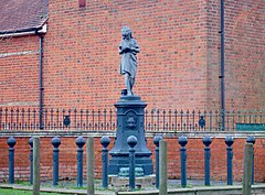
 Statue near Pirbright village hall | |
 The Basingstoke Canal divides the communities of Pirbright | |
Location within Surrey | |
| Area | 19.01 km2 (7.34 sq mi) |
| Population | 3,691 (Civil Parish 2011)[1] |
| • Density | 194/km2 (500/sq mi) |
| OS grid reference | SU950550 |
| Civil parish |
|
| District | |
| Shire county | |
| Region | |
| Country | England |
| Sovereign state | United Kingdom |
| Post town | Woking |
| Postcode district | GU24 |
| Dialling code | 01483 |
| Police | Surrey |
| Fire | Surrey |
| Ambulance | South East Coast |
| UK Parliament | |
Pirbright (/ˈpɜːrbraɪt/) is a village in Surrey, England. Pirbright is in the borough of Guildford and has a civil parish council covering the traditional boundaries of the area. Pirbright contains one buffered sub-locality, Stanford Common near the nation's farm animal disease research institute. The village's grade II* listed medieval church has a large Boulder grave for explorer Henry Morton Stanley. The nearby Hodge Brook is marked as Congo Stream, between Ruwenzori and Stanley Hills.
- ^ Key Statistics; Quick Statistics: Population Density United Kingdom Census 2011 Office for National Statistics Retrieved 21 November 2013
- ^ "Pirbright Parish Council - Home". Parish-council.com. Retrieved 28 February 2019.
© MMXXIII Rich X Search. We shall prevail. All rights reserved. Rich X Search
