Back برييدور Arabic برييدور ARZ Priedor Azerbaijani Приедор Bashkir Прыедар Byelorussian Прыедар BE-X-OLD Приедор Bulgarian Prijedor BS Prijedor Catalan Prijedor (lungsod sa Bosniya ug Ersogobina) CEB
This article needs additional citations for verification. (December 2022) |
Prijedor
Приједор (Serbian) | |
|---|---|
| Grad Prijedor Град Приједор City of Prijedor | |
|
Prijedor | |
 | |
 | |
| Coordinates: 44°58′51″N 16°42′48″E / 44.98083°N 16.71333°E | |
| Country | |
| Entity | |
| Geographical region | Bosanska Krajina |
| City status | July 2012 |
| Government | |
| • Mayor | Slobodan Javor[1] (SNSD) |
| Area | |
| • City | 834.06 km2 (322.03 sq mi) |
| Elevation | 136 m (446 ft) |
| Population (2013 census) | |
| • City | 89,397 |
| • Density | 110/km2 (280/sq mi) |
| • Urban | 32,342 |
| Time zone | UTC+1 (CET) |
| • Summer (DST) | UTC+2 (CEST) |
| Area code | +387 052 |
| Website | www |


Prijedor (Serbian Cyrillic: Приједор, pronounced [prijěːdor] ⓘ) is a city and municipality in Republika Srpska, Bosnia and Herzegovina. As of 2013, it had a population of 89,397 inhabitants within its administrative limits.[2][3] Prijedor is situated in the northwestern part of the Bosanska Krajina geographical region.
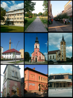
Prijedor is known for its mixed religious heritage comprising Eastern Orthodox Christianity, Roman Catholicism and Islam. Historic buildings from the Ottoman and Austrian-Hungarian periods are a feature of the urban landscape. The city underwent extensive renovation between 2006 and 2009.
- ^ Katarina Panic (2022-01-31). "Bosnian Mayor's Sacking Over Selfies Reveals Digital Age's Political Impact". BalkanInsight. Retrieved 2023-01-11.
- ^ "Saopstenje : First Releases" (PDF). Bhas.ba. Archived from the original (PDF) on 2018-11-23. Retrieved 2013-11-23.
- ^ "Prijedor Danas". opstinaprijedor.org. Archived from the original on November 17, 2011.
© MMXXIII Rich X Search. We shall prevail. All rights reserved. Rich X Search


