Back Saguenayrivier Afrikaans نهر ساجوينى ARZ Сагеней Bulgarian Riu Saguenay Catalan Rivière Saguenay CEB Saguenay (řeka) Czech Сагеней (юханшыв) CV Saguenay (flod) Danish Rivière Saguenay German Río Saguenay Spanish
| Saguenay River Saki-nip, Pitchitaouichetz (Innu-aimun) Kouate, Kyokiaye, Ouatheronnon (Wendat) Ktadoosôk (Mi'kmawi'simk) | |
|---|---|
 Saguenay River, inside the Saguenay–St. Lawrence Marine Park | |
 | |
| Etymology | Innu: leaving water, watersource; river of death; river flowing between two mountain ranges[1][2] Wendat: a large distance away; multiple spruces; opening, hole[3][4][5] |
| Native name | Rivière Saguenay (French) |
| Location | |
| Country | Canada |
| Province | Quebec |
| Region | Saguenay–Lac-Saint-Jean |
| Physical characteristics | |
| Source | Lac Saint-Jean |
| • location | Alma, Saguenay–Lac-Saint-Jean |
| • coordinates | 48°32′28″N 71°36′54″W / 48.54111°N 71.61500°W |
| • elevation | 102 m |
| Mouth | Saint Lawrence River |
• location | Tadoussac / Baie-Sainte-Catherine, Côte-Nord / Capitale-Nationale |
• coordinates | 48°07′45″N 69°42′13″W / 48.12917°N 69.70361°W |
• elevation | 3 m |
| Length | 170 km (110 mi)[6] |
| Basin size | 88,000 km2 (34,000 sq mi)[7] |
| Discharge | |
| • location | Saint Lawrence River[7] |
| • average | 1,750 m3/s (62,000 cu ft/s) |
| Basin features | |
| Tributaries | |
| • left | (upstream) ruisseau du Lac de l'Aqueduc, outlet of Lac de l'Anse à l'Eau, outlet of Petit lac de la Pointe à la Croix, outlet of Lac de la Boule, stream Desgagnés, ruisseau de l'Anse Creuse, cours d'eau Paul-Simard, outlet of Lac à Charlie, outlet of Lac des Mouches, Sainte-Marguerite, stream Gagnon, outlet of Lac de l'Anse à René, outlet of Lac Betty Baldwin, ruisseau de l'Ermite, outlet of Lac de la Voile, stream Biscambi, stream Fortin, stream Lac à Thomas, lake Damiens, outlet of Le Grand Lac, outlet of lake Pluto, stream Rouge, ruisseau à la Mine, rivière de la Descente des Femmes, outlet of lake Poléon, stream Neil, Pelletier River, décharge du lac José, ruisseau des îles, ruisseau Glissant, ruisseau du Moulin, rivière aux Outardes, stream Lajoie, Valin River, Caribou River, stream Sauvage, ruisseau à Paul, Michaud River (Saguenay River), rivière aux Vases (Saguenay River), Shipshaw River, outlet of lake Virgule, rivière des Aulnaies, stream des Portes de l'Enfer, outlet of lake Marcelle, stream Duclos, stream Gauthier, ruisseau du Lac Lucie, ruisseau de la Savane, ruisseau Gervais, outlet of lake Cimon, cours d'eau Beaumont, cours d'eau Larouche, cours d'eau Bouchard, cours d'eau Desbiens, Mistouk River, rivière aux Harts, rivière aux Chicots, stream Rouge. |
| • right | (upstream) Petites Îles River, Saint-Étienne River, Saint-Athanase River, Petit Saguenay River, Saint-Jean River, Éternité River, stream Aimable, rivière à la Croix, ruisseau aux Cailles, Ha! Ha! River, rivière à Mars, rivière à Benjamin, rivière du Moulin, rivière aux Rats, Chicoutimi River, rivière aux Sables, La Petite Décharge. |
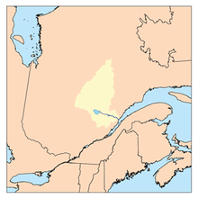
The Saguenay River (French: Rivière Saguenay, [ʁivjɛʁ saɡnɛ]) is a major river of Quebec, Canada. It drains Lac Saint-Jean in the Laurentian Highlands, leaving at Alma and running east; the city of Saguenay is located on the river. It drains into the Saint Lawrence River. Tadoussac, founded as a French colonial trading post in 1600, is located on the northeast bank at this site.
The river has a very high flow-rate and is bordered by steep cliffs associated with the Saguenay Graben. Tide waters flow in its fjord upriver as far as Chicoutimi (about 100 kilometres). Many Beluga whales breed in the cold waters at its mouth, making Tadoussac a popular site for whale watching and sea kayaking; Greenland sharks also frequent the depths of the river. The area of the confluence of the Saguenay and Saint Lawrence is protected by the Saguenay–St. Lawrence Marine Park, one of Canada's national parks.
- ^ "Rivière Saguenay". Commission de toponymie. Gouvernement du Québec. Retrieved 5 January 2023.
- ^ "Pitchitaouichetz". Commission de toponymie. Gouvernement du Québec. Retrieved 5 January 2023.
- ^ "Kouate". Commission de toponymie. Gouvernement du Québec. Retrieved 5 January 2023.
- ^ "Kyokiaye". Commission de toponymie. Gouvernement du Québec. Retrieved 5 January 2023.
- ^ "Ouatheronnon". Commission de toponymie. Gouvernement du Québec. Retrieved 5 January 2023.
- ^ Scheffel, Richard L.; Wernet, Susan J., eds. (1980). Natural Wonders of the World. United States of America: Reader's Digest Association, Inc. pp. 328–329. ISBN 0-89577-087-3.
- ^ a b Natural Resources Canada, Atlas of Canada - Rivers Archived 2012-03-29 at the Wayback Machine
© MMXXIII Rich X Search. We shall prevail. All rights reserved. Rich X Search