Back سنجين Arabic سنجين ARZ Sangin AST Sangīn (kapital sa distrito) CEB Sangin Czech Sangīn Spanish سنگین Persian Sangin French Sangin Italian سنگين Pashto/Pushto
Sangin | |
|---|---|
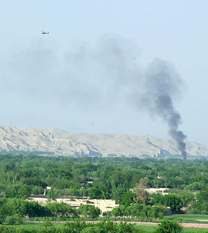
 Sangin District Centre during a fight between British troops and the Taliban in 2007 | |
| Coordinates: 32°4′24″N 64°50′2″E / 32.07333°N 64.83389°E | |
| Country | |
| Province | Helmand Province |
| District | Sangin District |
| Elevation | 2,913 ft (888 m) |
| Population | |
| • Total | 20,000 |
| Time zone | UTC+4:30 |
Sangin (Pashto: سنگين) is a town in Helmand province of Afghanistan, with a population of approximately 20,000 people.[1] It is located on 32°4′24″N 64°50′2″E / 32.07333°N 64.83389°E in the valley of the Helmand River at 888 m (2,913 ft) altitude, 95 km (59 mi) to the north-east of Lashkargah. Sangin is notorious as one of the central locations of the opium trade in the south of the country, and is also a town that has traditionally supported the Taliban.[2] It was described by British newspaper The Guardian as "the deadliest area in Afghanistan" in 2010.[3] Sangin also houses the main bazaar for Sangin District. Route 611 passes through Sangin.
- ^ Boone, Jon; Norton-Taylor, Richard (20 September 2010). "Sangin – town that became a death trap for UK soldiers – passed to US". The Guardian. Retrieved 2 April 2020.
- ^ Geopium - Jane's Intelligence Review - Opiate smuggling routes from Afghanistan to Europe and Asia Archived 2003-12-09 at the Wayback Machine
- ^ "Royal Marines speak of 'horrible' reality of life on patrol in Afghanistan". The Guardian. 17 November 2010.
© MMXXIII Rich X Search. We shall prevail. All rights reserved. Rich X Search
