Back See van Marmara Afrikaans የማርማራ ባሕር Amharic Mar de Marmara AN Proponditis ANG بحر مرمرة Arabic بحر مرمره ARZ Mar de Mármara AST Mərmərə dənizi Azerbaijani مرمره دنیزی AZB Мәрмәр диңгеҙе Bashkir
| Sea of Marmara | |
|---|---|
| Marmara Denizi (Turkish) | |
 | |
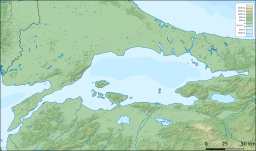
 Bathymetry and surrounding relief | |
| Location | Southern Europe and West Asia |
| Coordinates | 40°40′N 28°00′E / 40.667°N 28.000°E |
| Type | Inland sea |
| Primary inflows | Simav River, Biga Çayı, Nilüfer River |
| Primary outflows | Turkish Straits |
| Catchment area | 11,500 km2 (4,400 sq mi) |
| Basin countries | Turkey |
| Surface area | 11,350 km2 (4,380 sq mi) |
| Average depth | 494 m (1,621 ft) |
| Max. depth | 1,370 m (4,490 ft) |
| Water volume | 3,378 km3 (810 cu mi) |
| Islands | Marmara Island, Avşa, İmralı, Prince Islands, Paşalimanı and Ekinlik Island |
| Settlements | Istanbul, Bursa, İzmit, Tekirdağ, Balıkesir, Çanakkale, and Yalova |

Satellite image of the Sea of Marmara

Algal bloom on the Sea of Marmara

The Sea of Marmara,[a] also known as the Sea of Marmora or the Marmara Sea, is a small inland sea located entirely within the borders of Turkey. It connects the Black Sea to the Aegean Sea via the Bosporus and Dardanelles straits, separating Turkey’s European and Asian sides. It has an area of 11,350 km2 (4,380 sq mi), and its dimensions are 280 km × 80 km (174 mi × 50 mi).[1] Its greatest depth is 1,370 m (4,490 ft).
Cite error: There are <ref group=lower-alpha> tags or {{efn}} templates on this page, but the references will not show without a {{reflist|group=lower-alpha}} template or {{notelist}} template (see the help page).
- ^ "Marmara, Sea of - Dictionary definition of Marmara, Sea of - Encyclopedia.com: FREE online dictionary". www.encyclopedia.com. Retrieved 3 January 2018.
© MMXXIII Rich X Search. We shall prevail. All rights reserved. Rich X Search
