Back Somme ALS نهر السوم Arabic نهر السوم ARZ Somma çayı Azerbaijani Сома (рака) Byelorussian Сома (рака) BE-X-OLD Сома Bulgarian Somme (stêr) Breton Somme (riu) Catalan Сомма (эрк) CE
You can help expand this article with text translated from the corresponding article in French. Click [show] for important translation instructions.
|
| Somme | |
|---|---|
 The Somme | |
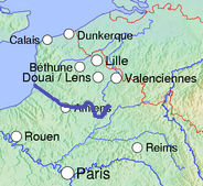
 Course in Northern France | |
| Location | |
| Country | France |
| Region | Picardy |
| Physical characteristics | |
| Source | |
| • location | Fonsommes |
| • coordinates | 49°54′23″N 03°24′11″E / 49.90639°N 3.40306°E |
| • elevation | 85 m (279 ft) |
| Mouth | |
• location | Saint-Valery-sur-Somme English Channel |
• coordinates | 50°11′10″N 01°38′35″E / 50.18611°N 1.64306°E |
| Length | 245 km (152 mi) |
| Basin size | 6,550 km2 (2,530 sq mi) |
| Discharge | |
| • location | Abbeville |
| • average | 35 m3/s (1,200 cu ft/s) |
The Somme (UK: /sɒm/ SOM, US: /sʌm/ SUM,[1][2] French: [sɔm] ⓘ) is a river in Picardy, northern France.
The river is 245 km (152 mi) in length, from its source in the high ground of the former Arrouaise Forest at Fonsomme near Saint-Quentin, to the Bay of the Somme, in the English Channel. It lies in the geological syncline which also forms the Solent. This gives it a fairly constant and gentle gradient where several fluvial terraces have been identified.[3]
- ^ Wells, John C. (2008). Longman Pronunciation Dictionary (3rd ed.). Longman. ISBN 978-1-4058-8118-0.
- ^ Jones, Daniel (2011). Roach, Peter; Setter, Jane; Esling, John (eds.). Cambridge English Pronouncing Dictionary (18th ed.). Cambridge University Press. ISBN 978-0-521-15255-6.
- ^ Gargani J.; Stab O; Cojan I.n Brulhet J. (2006). "Modelling the long-term fluvial erosion of the river Somme during the last million years". Terra Nova. 18 (2): 118–129. Bibcode:2006TeNov..18..118G. doi:10.1111/j.1365-3121.2006.00671.x. S2CID 130418864.
© MMXXIII Rich X Search. We shall prevail. All rights reserved. Rich X Search