Back Ville-Marie (Montreal) Afrikaans فيل-ماري (مونتريال) Arabic فيل مارى ARZ Ville-Marie (Montreal) German Ville-Marie (Montreal) Spanish Ville-Marie Estonian Ville-Marie (arrondissement) French Ville-Marie (dzielnica) Polish Ville-Marie (Montreal) Portuguese Вил Мари (Монтреал) Serbian
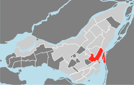
Ville-Marie is the name of a borough (arrondissement) in the centre of Montreal, Quebec. The borough is named after Fort Ville-Marie, the French settlement that would later become Montreal (now Old Montreal), which was located within the present-day borough. Old Montreal is a National Historic Site of Canada.
The borough comprises all of downtown Montreal, including the Quartier des spectacles; Old Montreal and the Old Port; the Centre-Sud area; most of Mount Royal Park as well as Saint Helen's Island and Île Notre-Dame.
In 2016, it had a population of 89,170 and an area of 16.5 square kilometres (6.4 sq mi).[4]
- ^ "Ministère des Affaires Municipales et Régions: Ville-Marie (Montreal)". gouv.qc.ca. Retrieved 13 April 2018.
- ^ "History of Federal Ridings since 1867". www2.parl.gc.ca. Retrieved 13 April 2018.
- ^ "Chief Electoral Officer of Québec - 40th General Election Riding Results: WESTMOUNT--SAINT-LOUIS". electionsquebec.qc.ca. Retrieved 13 April 2018.
Chief Electoral Officer of Québec - 40th General Election Riding Results: SAINTE-MARIE--SAINT-JACQUES
Chief Electoral Officer of Québec - 40th General Election Riding Results: HOCHELOGA-MAISONNEUVE
Chief Electoral Officer of Québec - 40th General Election Riding Results: SAINT-HENRI--SAINTE-ANNE - ^ a b c "PROFIL SOCIODÉMOGRAPHIQUE - Recensement 2016 - Arrondissement de Ville-Marie" (PDF). Canada 2016 Census (in French). Ville de Montréal. 2012. Retrieved 14 February 2020.
- ^ "Population totale en 2006 et en 2011 - Variation — Densité" (PDF). Canada 2011 Census (in French). Ville de Montréal. 2012. Retrieved 5 June 2012.
- ^ "Québec 511 - Carte routière". www.quebec511.gouv.qc.ca. Gouvernement du Québec, Ministère des Transports, de la Mobilité durable et de l'Électrification des. Retrieved 13 April 2018.
© MMXXIII Rich X Search. We shall prevail. All rights reserved. Rich X Search

