Back Elba Afrikaans Elba ALS Elba ANG إلبا Arabic إيلبا ARY ايلبا ARZ Islla d'Elba AST Elba BAR Эльба (востраў) Byelorussian Елба (остров) Bulgarian
Native name: Isola d'Elba | |
|---|---|
 Seen from the west, Monte Capanne in foreground | |
 | |
| Geography | |
| Location | Tyrrhenian Sea |
| Coordinates | 42°46′48″N 10°16′30″E / 42.78000°N 10.27500°E |
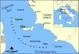
| Archipelago | Tuscan Archipelago |
| Total islands | 7 |
| Major islands | Elba, Gorgona, Capraia, Pianosa, Montecristo, Isola del Giglio, and Giannutri |
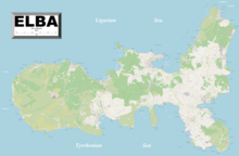
| Area | 224 km2 (86 sq mi) |
| Length | 29 km (18 mi) |
| Width | 18 km (11.2 mi) |
| Coastline | 147 km (91.3 mi) |
| Highest elevation | 1,018 m (3340 ft) |
| Highest point | Monte Capanne |
| Administration | |
Italy | |
| Region | Tuscany |
| Province | Livorno |
| Communes of Elba | Portoferraio, Campo nell'Elba, Capoliveri, Marciana, Marciana Marina, Porto Azzurro, Rio |
| Largest settlement | Portoferraio (pop. 12,011) |
| Demographics | |
| Population | 31,592 (January 2019[1]) |
| Pop. density | 140/km2 (360/sq mi) |

Elba (Italian: isola d'Elba, pronounced [ˈiːzola ˈdelba]; Latin: Ilva) is a Mediterranean island in Tuscany, Italy, 10 km (6.2 mi) from the coastal town of Piombino on the Italian mainland, and the largest island of the Tuscan Archipelago. It is also part of the Arcipelago Toscano National Park,[2] and the third largest island in Italy, after Sicily and Sardinia. It is located in the Tyrrhenian Sea about 50 km (30 mi) east of the French island of Corsica.
The island is part of the province of Livorno and is divided into seven municipalities, with a total population of about 30,000 inhabitants which increases considerably during the summer. The municipalities are Portoferraio (which is also the island's principal town), Campo nell'Elba, Capoliveri, Marciana, Marciana Marina, Porto Azzurro, and Rio.
Elba was the site of Napoleon's first exile, from 1814 to 1815.
- ^ "Istat official population estimates". Archived from the original on 24 July 2019. Retrieved 30 March 2020.
- ^ "Elba". Parco nazionale dell'Arcipelago Toscano. 16 February 2009. Archived from the original on 28 May 2013. Retrieved 15 January 2012.
© MMXXIII Rich X Search. We shall prevail. All rights reserved. Rich X Search