Back مقاطعة ميرسر (نيو جيرسي) Arabic Merser (dairə, Nyu-Cersi) Azerbaijani Mercer County, New Jersey BAR Мърсър (окръг, Ню Джърси) Bulgarian মারর্সের কাউন্টি, নিউ জার্সি BPY Mercer Gông (New Jersey) CDO Мерсер (гуо, Нью-Джерси) CE Mercer County (kondado sa Tinipong Bansa, New Jersey) CEB Mercer County (New Jersey) Czech Mercer County, New Jersey Welsh
Mercer County | |
|---|---|
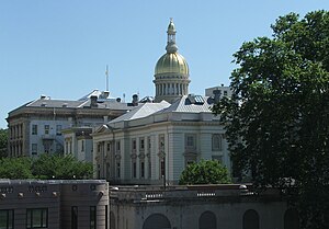
 The New Jersey State House and its golden dome at Trenton in 2006 | |
| Nickname: The Capital County[1] | |
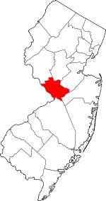
 Location within the U.S. state of New Jersey | |
 New Jersey's location within the U.S. | |
| Coordinates: 40°17′N 74°42′W / 40.28°N 74.70°W | |
| Country | |
| State | |
| Founded | 1838 |
| Named for | Hugh Mercer |
| Seat | Trenton[2] |
| Largest municipality | Hamilton Township (population) Hopewell Township (area) |
| Government | |
| • County executive | Daniel R. Benson (D, term ends December 31, 2027) |
| Area | |
| • Total | 228.86 sq mi (592.7 km2) |
| • Land | 224.44 sq mi (581.3 km2) |
| • Water | 4.42 sq mi (11.4 km2) 1.9% |
| Population | |
| • Total | 387,340 |
| • Estimate | 381,671 |
| • Density | 1,724.9/sq mi (666.0/km2) |
| Congressional districts | 3rd, 12th |
| Website | www |
Mercer County is a county located in the U.S. state of New Jersey. Its county seat is Trenton, also the state capital,[2] prompting its nickname The Capital County.[1] Mercer County alone constitutes the Trenton–Princeton metropolitan statistical area[7] and is considered part of the New York combined statistical area by the U.S. Census Bureau,[8][9][10] but also directly borders the Philadelphia metropolitan area and is included within the Federal Communications Commission's Philadelphia Designated Media Market Area.[11] The county is part of the Central Jersey region of the state.[12][13]
As of the 2020 United States census, the county retained its position as the state's 12th-most-populous county,[14] with a population of 387,340,[4][5] its highest decennial count ever and an increase of 20,827 (+5.7%) from the 366,513 recorded at the 2010 census,[15] which in turn had reflected an increase of 15,752 (+4.5%) from the 350,761 enumerated at the 2000 census[16][17][18] The most populous municipality in Mercer County at the 2020 census was Hamilton Township, with 92,297 residents,[5] while Hopewell Township was the largest in area.[3]
The county was formed by an act of the New Jersey Legislature on February 22, 1838, from portions of Burlington County (Nottingham Township, now Hamilton Township), Hunterdon County (Ewing Township, Lawrence Township, Trenton, and portions of Hopewell Township), and Middlesex County (West Windsor Township and portions of East Windsor Township).[19] The former Keith Line bisects the county and is the boundary between municipalities that previously had been separated into West Jersey and East Jersey.
Trenton–Mercer Airport in Ewing Township is a commercial and corporate aviation airport serving Mercer County and its surrounding vicinity. The official residence of the governor of New Jersey, known as Drumthwacket, is located in Princeton, and is listed on both the U.S. National Register of Historic Places and the New Jersey Register of Historic Places. Mercer County contains 12 municipalities, the fewest of any county in New Jersey, and equal to Hudson County.


- ^ a b "Mercer County "The Capital County"". County of Mercer, New Jersey. Retrieved September 15, 2021.
- ^ a b New Jersey County Map, New Jersey Department of State. Accessed December 22, 2022.
- ^ a b Cite error: The named reference
CensusAreawas invoked but never defined (see the help page). - ^ a b c Cite error: The named reference
Census2020was invoked but never defined (see the help page). - ^ a b c Cite error: The named reference
LWD2020was invoked but never defined (see the help page). - ^ Cite error: The named reference
PopEstwas invoked but never defined (see the help page). - ^ Revised Delineations of Metropolitan Statistical Areas, Micropolitan Statistical Areas, and Combined Statistical Areas, and Guidance on Uses of the Delineations of These Areas
- ^ (Note: Mercer County, NJ is NOT part of the Philadelphia CSA according to this original source.) "Revised Delineations of Metropolitan Statistical Areas, Micropolitan Statistical Areas, and Combined Statistical Areas, and Guidance on Uses of the Delineations of These Areas", OMB Bulletin no. 18-04, The White House, Office of Management and Budget, September 4, 2018
- ^ NEW JERSEY - Core Based Statistical Areas (CBSAs) and Counties Archived July 23, 2017, at the Wayback Machine, United States Census Bureau, February 2013. Accessed August 8, 2017.
- ^ Combined Statistical Areas of the United States and Puerto Rico Archived April 30, 2018, at the Wayback Machine, United States Census Bureau, July 2015. Accessed August 8, 2017.
- ^ - Philadelphia Market Area Coverage Maps Archived May 24, 2014, at the Wayback Machine, Federal Communications Commission. Accessed December 28, 2014.
- ^ Governor Murphy Settles Central Jersey Debate, Governor of New Jersey Phil Murphy, press release dated August 4, 2023. "Governor Phil Murphy today signed S3206 to promote Central Jersey tourism.... The 'Central Jersey' region will be comprised of, at minimum, the counties of Hunterdon, Mercer, Middlesex, and Somerset."
- ^ Willis, David P. "'This is how wars start': Does Central Jersey include both Ocean and Union counties?", Asbury Park Press, February 20, 2023. Accessed March 31, 2024. "North Jersey is defined as Sussex, Warren, Morris, Passaic, Bergen, Essex and Hudson counties; South Jersey would be Burlington, Camden, Gloucester, Atlantic, Salem, Cumberland and Cape May counties. But for Central, things get a little tricky. It would include Hunterdon, Somerset, Union, Middlesex, Mercer, Monmouth, and Ocean counties."
- ^ Table 1. New Jersey Counties and Most Populous Cities and Townships: 2020 and 2010 Censuses, New Jersey Department of Labor and Workforce Development. Accessed December 1, 2022.
- ^ Cite error: The named reference
Census2010was invoked but never defined (see the help page). - ^ DP-1 - Profile of General Demographic Characteristics: 2000; Census 2000 Summary File 1 (SF 1) 100-Percent Data for Mercer County, New Jersey, United States Census Bureau. Accessed January 21, 2013.
- ^ NJ Labor Market Views Archived September 20, 2013, at the Wayback Machine, New Jersey Department of Labor and Workforce Development, March 15, 2011. Accessed October 6, 2013.
- ^ Cite error: The named reference
CPH232was invoked but never defined (see the help page). - ^ Snyder, John P. The Story of New Jersey's Civil Boundaries: 1606-1968 Archived June 5, 2012, at the Wayback Machine, Bureau of Geology and Topography; Trenton, New Jersey; 1969. p. 161. Accessed October 1, 2013.
- ^ "Princeton University". U.S. News & World Report. Retrieved September 10, 2018.
© MMXXIII Rich X Search. We shall prevail. All rights reserved. Rich X Search

