Back Antarktiese Sirkel Afrikaans الدائرة القطبية الجنوبية Arabic Círculu polar antárticu AST Cənub Qütb dairəsi Azerbaijani Көньяҡ поляр түңәрәк Bashkir Sirkulong Antartiko BCL Паўднёвы палярны круг Byelorussian Паўднёвы палярны круг BE-X-OLD Южен полярен кръг Bulgarian কুমেরু বৃত্ত Bengali/Bangla

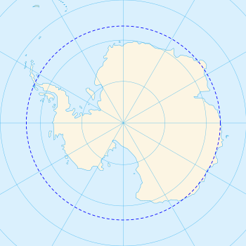
The Antarctic Circle is the most southerly of the five major circles of latitude that mark maps of Earth. The region south of this circle is known as the Antarctic, and the zone immediately to the north is called the Southern Temperate Zone. South of the Antarctic Circle, the Sun is above the horizon for 24 continuous hours at least once per year (and therefore visible at midnight) and the centre of the Sun (ignoring refraction) is below the horizon for 24 continuous hours at least once per year (and therefore not visible at noon); this is also true within the equivalent polar circle in the Northern Hemisphere, the Arctic Circle.
The position of the Antarctic Circle is not fixed and currently runs 66°33′50.0″ south of the Equator.[1] This figure may be slightly inaccurate because it does not allow for the effects of astronomical nutation, which can be up to 10″. Its latitude depends on the Earth's axial tilt, which fluctuates within a margin of more than 2° over a 41,000-year period, due to tidal forces resulting from the orbit of the Moon.[2] Consequently, the Antarctic Circle is currently drifting southwards at a speed of about 14.5 m (48 ft) per year.
- ^ "Obliquity of the Ecliptic (Eps Mean)". Neoprogrammics.com. Archived from the original on 2017-06-12. Retrieved 2014-05-13.
- ^ Berger, A.L. (1976). "Obliquity and Precession for the Last 5000000 Years". Astronomy and Astrophysics. 51 (1): 127–135. Bibcode:1976A&A....51..127B.
© MMXXIII Rich X Search. We shall prevail. All rights reserved. Rich X Search