Back Iwano-Frankifsk Afrikaans إيفانو فرانكيفسك Arabic Ivano-Frankivsk AST İvano-Frankovsk Azerbaijani Ивано-Франковск Bashkir Івана-Франкоўск Byelorussian Івана-Франкоўск BE-X-OLD Ивано-Франкивск Bulgarian Ivano-Frankivsk Catalan Ивано-Франковск CE
Ivano-Frankivsk
Івано-Франківськ | |
|---|---|
| |
|
| |
| Nickname(s): Frankivsk (Франківськ), Franyk (Франик), Stanyslaviv (Станиславів) | |
| Coordinates: 48°55′22″N 24°42′38″E / 48.92278°N 24.71056°E | |
| Country | |
| Oblast | Ivano-Frankivsk Oblast |
| Raion | Ivano-Frankivsk Raion |
| Hromada | Ivano-Frankivsk urban hromada |
| Established | 1662 |
| Subdivisions | List
|
| Government | |
| • Mayor | Ruslan Martsinkiv (Svoboda)[1] |
| Area | |
| • Total | 83.7 km2 (32.3 sq mi) |
| Elevation | 260 m (850 ft) |
| Population (2022) | |
| • Total | 238,196 |
| • Density | 2,800/km2 (7,400/sq mi) |
| Time zone | UTC+2 (EET) |
| • Summer (DST) | UTC+3 (EEST) |
| Postal code | 76000–76030 |
| Area code | +380 342 |
| Website | mvk |
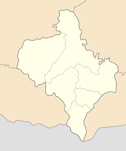
Ivano-Frankivsk (Ukrainian: Івано-Франківськ, IPA: [iˈwɑno frɐnˈkiu̯sʲk] ⓘ), formerly Stanyslaviv, Stanislav and Stanisławów,[a][2][3] is a city in western Ukraine.[4] It serves as the administrative centre of Ivano-Frankivsk Oblast as well as Ivano-Frankivsk Raion within the oblast. Ivano-Frankivsk also hosts the administration of Ivano-Frankivsk urban hromada.[5] Its population is 238,196 (2022 estimate).[6]
Built in the mid-17th century as a fortress of the Polish Potocki family, Stanisławów was annexed to the Habsburg Empire during the First Partition of Poland in 1772, after which it became the property of the State within the Austrian Empire. The fortress was slowly transformed into one of the most prominent cities at the foothills of the Carpathian Mountains. After World War I, for several months, it served as a temporary capital of the West Ukrainian People's Republic. Following the Peace of Riga in 1921, Stanisławów became part of the Second Polish Republic. After the Soviet invasion of Poland at the onset of World War II, the city was annexed by the Soviet Union, only to be occupied by Nazi Germany two years later. With the liberation of Soviet Ukraine in 1944 and the shifting of borders, the city remained part of the Ukrainian SSR and was renamed in 1962 after Ivan Franko. With the fall of the Soviet Union in 1991, the city become part of newly independent Ukraine.
Ivano-Frankivsk is one of the principal cities of the Carpathian Euroregion. There are elements of various cultures intertwined in the city's architecture, including the Polish city hall, the Austro-Hungarian city's business centre, the Soviet prefabricated apartment blocks at the city's rural–urban fringe, and others.
- ^ Cite error: The named reference
hromadske.mer-ivano-frankivskawas invoked but never defined (see the help page). - ^ "Ivano-Frankivsk". britannica.com.
- ^ The Sad End of the Orange Revolution, Der Spiegel (14 January 2010)
- ^ "The City of Ivano-Frankivsk". sbedif.if.ua. Archived from the original on April 16, 2000. Retrieved March 7, 2010.
- ^ "Ивано-Франковская городская громада" (in Russian). Портал об'єднаних громад України.
- ^ Чисельність наявного населення України на 1 січня 2022 [Number of Present Population of Ukraine, as of January 1, 2022] (PDF) (in Ukrainian and English). Kyiv: State Statistics Service of Ukraine. Archived (PDF) from the original on 4 July 2022.
Cite error: There are <ref group=lower-alpha> tags or {{efn}} templates on this page, but the references will not show without a {{reflist|group=lower-alpha}} template or {{notelist}} template (see the help page).
© MMXXIII Rich X Search. We shall prevail. All rights reserved. Rich X Search


