Back نهر كونكا ARZ Konka çayı Azerbaijani Конка Bulgarian Kins'ka CEB Kinska Czech Kinska Danish Kinska German Río Konka Spanish Konka jõgi Estonian Konka French
| Konka | |
|---|---|
 | |
| Location | |
| Country | Ukraine |
| Physical characteristics | |
| Source | |
| • location | Azov Upland |
| • coordinates | 47°19′48″N 36°26′46″E / 47.33000°N 36.44611°E |
| Mouth | Dnieper |
• coordinates | 47°38′20″N 35°15′50″E / 47.6388°N 35.2640°E |
| Length | 146 km (91 mi) |
| Basin size | 2,580 km2 (1,000 sq mi) |
| Basin features | |
| Progression | Dnieper→ Dnieper–Bug estuary→ Black Sea |
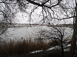
The Konka, also known as the Kinka, Kinska, or Kinski Vody[a] is a left tributary of the Dnieper, flowing through Zaporizhzhia Oblast, Ukraine. It is 146 km (91 mi) long, and has a drainage basin of 2,580 km2 (1,000 sq mi). It originates in the Azov Upland and flows into the Kakhovka Reservoir on the Dnieper. The cities of Polohy and Orikhiv are located on the river.[1]
The name is a calque of the Crimean Tatar name of the river Yilki Su, which means "water of wild horses".[2]
Cite error: There are <ref group=lower-alpha> tags or {{efn}} templates on this page, but the references will not show without a {{reflist|group=lower-alpha}} template or {{notelist}} template (see the help page).
- ^ "Конка". Great Soviet Encyclopedia.
- ^ Cite error: The named reference
argwas invoked but never defined (see the help page).
© MMXXIII Rich X Search. We shall prevail. All rights reserved. Rich X Search